

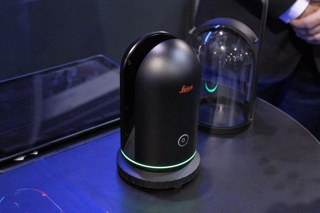
The news this week seems to be centered on the release of Leica’s new BLK360 scanner at Autodesk University. Oddly enough, I spent a bit of the week working with several new offerings from FARO. It would seem that we are seeing another major shift on the hardware side of things. While I intend to follow up with a “hands on” review of the Faro Freestyle and Scene in a forthcoming post, I’ve fielded several calls this week discussing the effects of new hardware on the market and to be frank, it’s a bit more interesting to speculate than report…
So, what does the Leica BLK360 tell us about the market (or at least Leica’s opinion of it)?
- The “This is Just Like GPS was” guys scored another point.
It’s essentially a one-button idiot box like the 3rd generation (and subsequent generations) of GPS receivers. Don’t take that as a bad thing. As a guy that is now training traditional survey crews to use laser scanners as opposed to the highly specialized scanner field techs that have been the staple of the business, I’m happy for an easier-to-use interface.
- A lot of your clients are about to get their own scanners.
I think the price point puts a lot of architects and construction firms in the collection game. The range and slower collection speed issues will probably limit the engineering adoption of the device, and I think the mining guys will have the same issues. At least the ones that haven’t already abandoned scanners for UAVs.
- The opportunity is great enough to break the reseller mold.
My understanding is that these will be sold through Autodesk and Leica direct and not through the reseller channels that Leica has used for every other piece of hardware to this point. My guess is that the pricing is much more aggressive on a profit margin basis that anything else they’ve released before so they chose to keep it all in house (with the exception of Autodesk). Once again, that makes since, given the sheer number of users Autodesk brings to the table.
Lastly, as a former reseller, I’m on the fence about this one. My first thought was that Leica finally had a hot, low-cost product with mass appeal out—and after all of the years of hawking their high-end stuff I’m cut out? But I can’t forget the experiences I’ve had selling lower cost hardware in the past. It seemed like it took as long to convert a sale for a DotProduct DPI-x as it did for a Leica C10. Now, if you’re getting say, 15% commission on each, are you going to spend your time selling a four figure product or a six figure product?
- The largest initial impact may be on the used scanner market.
Having recently changed jobs, I have been working the used market pretty hard over the past 3 months in an attempt to gain the hardware that I was accustomed to having access to in the past. I’ve run into a lot of used phase-based scanners that are 1-2 years old in the $40-50k range. Considering I was going to use most of them in a scan to BIM setting and now have the choice of a brand new unit that is completely serviceable for the job at $16k I can only assume that those used prices are going to fall. The longer range stuff will hold up a bit better but considering the new FAROS 350 that is promising millimeter accuracy along with the 350 meter range we may see their prices come down soon as well.
Does this mark the end of the scanning specialist that we have all been to this point? I don’t think it’s quite that Draconian. I’ll be one of those “This is Just Like GPS was” guys for a moment.
I remember when most of our (soon to be former) clients started buying their own GPS units. We had been Neiman Marcus and suddenly we were going to have to be Wal-Mart to survive and none of us found that very appealing. Then I found myself spending the next couple of years fixing problems that all of these surveyors with their new GPS receivers were creating. That led me to learn GIS, as most of the problems were in setting control for municipal GIS projects, and that made me want to add 3D data to my GIS databases, which led me to scanning. That’s the great thing about disruption, chances to jump around abound.


