
Last week’s Imaging and LiDAR Solutions Conference in Toronto, held by the newly minted Teledyne Optech, hosted a full afternoon of presentations about drones. Most surprisingly for this reporter, having followed the drone industry closely for more than a year already, the presentations felt fresh. There are a lot of possible uses for the technology, and just when you think you’ve heard them all, someone proves you wrong.
 A UAV Tethered to an SUV?
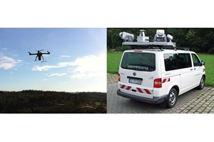
The most surprising presentation was given by Pere Molina, the advanced applications program manager at GeoNumerics. He presented on the mapKITE project, which his company is coordinating to develop “a tandem terrestrial-aerial system for high-resolution corridor mapping.”
Click through to our sister site, Expo UAV, to read more.


