New UAS photogrammetry software is getting so good you can perform high-quality scanning with very rudimentary cameras. But, when faced with any solution that promises to be faster, easier, and cheaper, we always need to ask: Is it accurate enough?
As Lewis Graham of GeoCue (and newly of AirGon) explained to a captive audience at ILMF, not just any simple consumer camera will suit your needs. None of the algorithms in these software packages can do magic, so you still need to take a great deal of care when selecting your camera.
So, how do you know when a camera is accurate enough?
The most important point of comparison was not what you’d expect. “Cameras are just like LiDAR systems,” Graham said. “From manufacturers there’s this one-upmanship, and usually it’s on the number of pixels that the array has. It turns out that unless you’re really concerned with the amount of coverage you can get in a particular length of time, that’s certainly not the most important parameter of camera selection.”
Stop looking for cameras with more megapixelsm because a camera’s suitability for 3D measurement lives and dies according to its pixel site size. This is the size of the actual sensor that captures photons. Imagine the pixel site as a bucket (as this handy website does)–a larger bucket captures more pixels, and so it gathers a stronger signal, less noise, and gives you higher accuracy. It’s all very scientific, but your takeaway is this: the bigger the pixel site size the better your results.
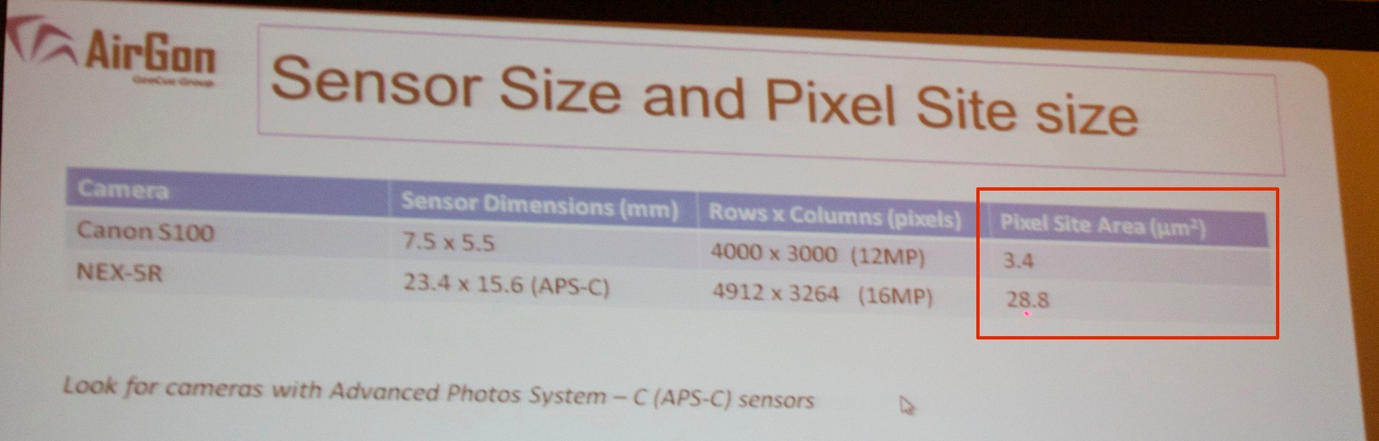
Midway through his presentation, Graham pointed to a slide showing camera sensor details for a Canon he didn’t choose for his company’s mapping kit, and a Sony he did. For pixel site area, “you notice there’s a huge difference between the two, and this turns out to be the differentiating quality in this camera, and for our particular area of interest, which is stockpile volumetrics.”
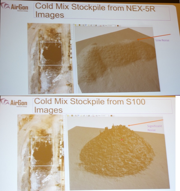
Measuring cold mix concrete, which Graham predicted to be a challenge, the Sony NEX-5R handily bested the Canon. The larger pixel site size led to a much smoother model, with much lower noise.
After performing an accuracy test, he found that the Sony’s margin of error was much, much smaller. “I looked at this data when we first ran it and I said, I don’t think this is possible. We’ve tested this at three different mine sites, and these numbers are relatively typical of what we do.”
But pixel size isn’t the only important stat to look for. “The achievable frame rate of the camera has an affect on the flying speed of the UAS. When the framerate of the camera is slower, you either have to fly higher or slower, if you’re using a fixed-wing, this can be a problem because you can get down to the stall speeds of the aircraft–and you’re done after that.”
Using a camera with a worse framerate can also reduce the amount of airtime you get with a roto-copter style UAS.
With these criteria, Graham says, there are plenty of options around the $1k mark, not just the Sony he uses. And you’ll want to keep the price down because you’re probably going to lose more than one to the inevitable UAV accident. “You use them because you lose them,” he said.
“We’ve lost, I think, three NEX cameras. I don’t mean lost–when you hit the mine wall they don’t do very well.”
Commercial UAV Expo, a new trade show and conference organized by SPAR 3D, will take place October 5-7, 2015 in Las Vegas. It focuses on the commercial UAV/UAS market in North America covering including Surveying & Mapping; Civil Engineering & Infrastructure; Mining; Construction; Process, Power & Utilities; Precision Agriculture; and Law Enforcement, Security, Emergency Response.