
Construction companies can derive a lot of value from knowing the position of their workers and contractors on the job site. This one piece of information shows the floor they’re on, the valve they’re standing in front of, the beam that they’re over. It’s simple, but powerful. Unfortunately, indoor position information has been historically hard to come by.
Redpoint’s Real-Time Location System (RTLS), what the company calls “indoor GPS,” might change that. It’s more scalable than SLAM, more accurate than wi-fi, and has a few tricks up its sleeve.
So, how does it work and what can it do?
How RTLS Works
RTLS exploits Ultra-Wideband (UWB) technology, which uses short radio pulses to obtain locations–much like radar.
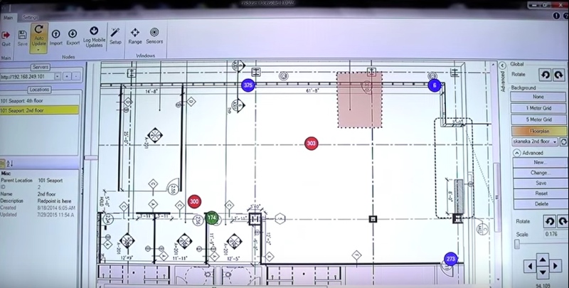
Tracking workers using Sitewise
As Redpoint explains it, the system works like this: “Radio transmitters referred to as anchors are placed inside of the building under construction. They are affixed at known locations within the structure at modeled control points.” Like the satellites used for GPS positioning, these anchors “transmit unique timing signals. Workers in the building carrying UWB receivers (or tags) receive those timing signals which then calculate a precise 3D position within the building model.”
That model you use to display the positions of workers can be within Redpoint’s own Sitewise software, or compatible software like Autodesk’s BIM 360.
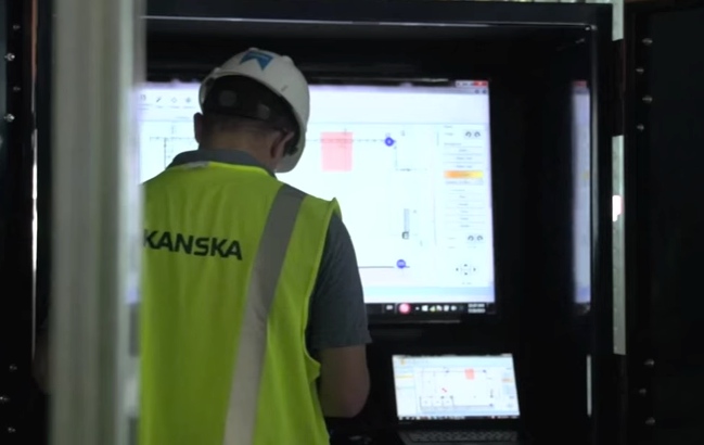
Here’s where it gets interesting: The RTLS system enables two-way communication. Tags can talk to each other, and they can talk to the anchors. This means you can pull up a tablet and know where everyone is on the worksite instantly.
As Redpoint explains, it also means that anchors can communicate with “a server recording data for the entire job-site,” which can be used to record “the complete history of position data for all the tags and their corresponding movements.”
A New Way to Interact with a 3D Model
The number of potential uses is huge. I don’t want to steal Redpoint’s thunder by explaining them all, because they have a very well written construction whitepaper exploring how you can use their RTLS to create a zone-based alerting system for safety, workforce analytics, and even how you can use it to manage your assets on site by tagging and tracking the movement of important materials.
Most interesting to me, though, is the way Redpoint’s system simplifies the process of reading and updating a 3D BIM model while on site.
The BIM models we use in the construction of a building are becoming increasingly rich. This is their main value but also their Achilles’ heel: the more complex the data, the more attention and expertise it requires to read. When you’re working on site, those are commodities that can be in short supply.
Redpoint’s indoor GPS offers a “you are here” point in the BIM model that saves you the time and trouble of locating your position manually. Simply pull up your BIM model on a smartphone or a tablet on site, and the device already knows where you are. “This new capability,” Redpoint writes, “will save contractor time by automating model navigation and will reduce errors due to location misidentification.”
An extra benefit is that you can make notes or take photos of known issues and have them automatically tagged to the correct location in the model, and communicated back to the master server.
Redpoint is so sure that this will simplify the usage of BIM onsite that they claim it will change “BIM model navigation from a chore into a can’t-live-without technology.”
Future-Facing
 As far as next steps, Redpoint has already integrated the tech with Autodesk’s Forge platform. For those of you who are unfamiliar, Forge allows users to cobble together their own web-based software solution by mixing and matching functions of Autodesk’s existing software. (For more on Forge, find our in-depth coverage here.)
Autodesk likely won’t be the only company supporting Redpoint’s technology, as the indoor GPS technology comes with an open API designed to make integration easy. Any software developer that wants to incorporate indoor-location information into its software can work with Redpoint to do that.
As I often say, once you put your technology in the hands of creative people with big ideas, there’s no telling what kinds of amazing things they’ll make it do.


