
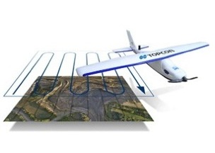
Topcon Positioning Group recently announced two new UAS for mapping, the Sirius Pro and Sirius Basic. They sound like pretty standard UAS for mapping, and the press release states that “both systems are designed to produce the most accurate solutions for the automated mapping of a wide range of sites — regardless of terrain — including construction sites, mines and quarries, and for use in land surveying, power line and pipeline inspection as well as precision agriculture field mapping.”
Both Sirius UAS solutions include a fixed-wing UAV that can be launched by hand. The systems also incorporates autopilot-assisted manual control, safety features for use in emergencies, and automatic flight planning with MAVinci software, courtesy of MAVinci Gmbh, a UAS development company that Topcon entered into an agreement with last October.
The focus of Topcon’s marketing campaign, however, is the RTK solution that they are calling “unique to the UAS marketplace.” The release continues: “Instead of using traditional ground control points, Topcon combines RTK (Real Time Kinematic) GNSS solutions with precision timing technology to provide more accurate mapping results when compared to other products.”
In October 2013, when Topcon and MAVinci first announced the Sirius Pro to the European market at Intergeo, their RTK solution was unique. Recently, however, there have been other comers: In June, for instance, Sensefly announced a version of their popular eBee with an RTK sensor. Click here to read the press release for the appropriately named eBee RTK.
As compared to smaller UAVs like the Sensefly, the main benefit of the Topcon Sirius UAVs seem to be their size: They are slightly larger and a bit heavier, making them ideal for use in situations with higher winds since they can maintain a more stable flight.
But the Sirius UAVs are still small, and so the payloads they carry are restricted. That is, they will not carry a LiDAR system, but will support a professional camera rig.
Correction, Sept 3, 2014: This article incorrectly stated that Sensefly was the first to release a UAS with an RTK solution. Topcon’s European announcement of the Sirius in October of 2013 actually predates the Sensefly eBee RTK, which was announced in June of this year.


