

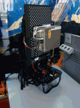
Google announced via their Lat/Long blog that they were using a new system called “Cartographer.” It’s an interesting kit that is a bit like a stripped down Viametris iMMS or the eMap system that I wrote about back in March 2013. All three use SLAM (Simultaneous Location and Mapping) technology for positioning, and they all seem to be relying on the Hokuyo UTM-30LX and UTM30-LX-EW sensors. It’s impossible to tell what’s in the metal box on the Cartographer, but TechCrunch reported that the unit has an IMU (Inertial Measurement Unit), which I assume is to account for the nonlinear movement of the backpack.
The first thing I think when I see this sort of project is all of negatives that come from reducing accuracy and data quality for the sake of speed and portability. However, after looking at the data that Google is delivering from this system, it occurs to me that they may not care about such things the way that I do, and maybe I should not care as much either!
For instance, take a look at the interior of the San Francisco Marriott Marquis that was collected via the Cartographer. Now, let’s think about the things that typically bother most of us about indoor mobile mapping systems. When the deliverable is reduced to linework and point of interest location information things like range noise, 3-6 cm registration errors and parallax errors start to seem a little irrelevant. It’s not that they don’t matter at all; it’s a matter of perspective. Many of us tend to compare this data to terrestrial (static) laser scans, and that does make it look dirty and generally of lower quality. However, if the deliverable is all the end user sees, shouldn’t the most cost effective solution win out – even if we technicians have an aesthetic issue with the raw data? To put it another way, I’m sure Google could build a system that supplied them with pristine data – there is a reason they built the Cartographer instead.
One feature that I hope others will look at is the real-time addition of metadata (i.e. point of interest information) that the user can add via a tablet while mapping with the Cartographer. While this is obviously more important to Google than most, I do think it would be a welcome addition for some of us in the asset management arena. It’s also interesting to me that the Cartographer does not seem to have a camera (unlike the other Google backpack mapper, the “Trekker” or the indoor mapping services they are promoting to businesses.
The question I’m left with is this: Will we early adopters be the ones that lead (and profit) when 3D imaging goes mainstream? Or are we going to dismiss the perfect tool for taking it mainstream because we are comparing it to our old tools instead of our new needs?


