

The fourth worldwide Global Navigation Satellite System that will join those undertaken by the United States—GPS, Russia— GLONASS and Europe—Galileo, will be the Chinese BeiDou. The system is named after the Big Dipper.
Beidou-2 (aka Compass) is the second generation of the BeiDou Navigation Satellite System (BDS). In 2007 Xinhua, the government news agency, announced that the People’s Republic of China National Space Administration would launch two more GEO satellites to open the way to a global Chinese Satellite Navigation system to replace the regional BeiDou-1, China’s current regional system.
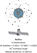
The first BeiDou-2 satellite, a medium Earth orbit (MEO) satellite named Compass-M1, was launched into a circular orbit at 21,500 km at an inclination of 55.5º. Similar satellites followed and between 2007 and 2012. There were 5 MEO satellites with sequential names from Compass-M1 to M6 (without an M2) launched. During the period from 2009 to 2012 the 6 GEO BeiDou-2 satellites with sequential names from Compass-G1 to G6 were launched. From 2010 to 2011 the 5 high Earth orbit (HEO) BeiDou-2 satellites with sequential names from Compass-IGS01 to IGS05 were launched an achieved an altitude of approximately 38,000 km. The acronym IGOS means inclined geosynchronous orbit satellites. The IGS01, IGS02 and IGS03 satellite are at ~120°E. IGS04 and IGS05 are at ~95°E. All the IGSO satellites have an inclination of 55° and are arranged so that one of them is always over the Chinese region. The system began trial operations in late 2011 and followed with service to region bounded by 55°E longitude to 180°E longitude and latitude 55°S to 55°N.
These launches are harbingers of a full BeiDou-2 constellation which will eventually include 35 satellites, 5 of them will be geostationary satellites (GEO) and 30 will be non-stationary. The constellation will occupy six orbital planes. The 30 non-stationary satellites will include 27 in medium Earth orbit (MEO) and 3 in inclined geosynchronous orbit (IGSO).
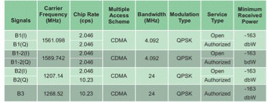
BeiDou satellites currently transmit signals in three bands; B1 (1561.098 MHz), B1-2 (1589.742 MHz), B2 (1207.14 MHz) and B3 (1268.52). These bands overlap Galileo on E2-L1-E1, E5B, and E6 respectively.
There are two service types. The Open Service is available to the public and offers an autonomous (not differentially corrected) positional accuracy of 10m, 0.2 m/s velocity accuracy, and timing accuracy within 20 nanoseconds. The Authorized service is not available to the public. It is available to the military, specifically the militaries of China and Pakistan.
There is a plan for a unique service that has not been incorporated into other GNSS systems, a wide area differential correction available directly from the constellation rather than from a separate system. The BeiDou Ground Based Enhancement System (BGBES) network includes 150 reference stations, information from these stations provided is processed in the BeiDou Control/Ground segment and the resulting corrections are sent to the BeiDou GEO satellites. Those corrections are then broadcast by the GEO satellites via the D2 NAV message to the BeiDou user’s terminals (receivers). In other words, the GEO satellites provide satellite based augmentation (SBAS) for users in the region between 70° E. Longitude to 145° E. Longitude and 5° N. Latitude to 55° N. Latitude. While the BeiDou’s open service is said to offer positional accuracy of ~10m the differentially corrected is expected to produce ~1m. Within the same region BeiDou also provides a short message service (SMS). Users are enabled to send up to 120 Chinese characters in each message. This two-way communication feature is unique.
The BeiDou Control/Ground Segment is comprised of a Master Control Station (MCS), two Upload Stations (US) and a network of 30 widely distributed Monitoring Stations (MS). Similar to the control of other GNSS constellations the MCS receives data from the Monitoring Stations which track the constellation continuously. The Upload Stations send the data generated information by the MCS to the satellites.
The MCS is responsible for the operational control of the system, including orbit determination, navigation messages and ephemerides which are based on the China Geodetic Coordinate System 2000 (CGCS2000). CGCS2000 is the coordinate framework of the BeiDou System and is within a few centimeters of ITRF. BeiDou Time is synchronized within 100ns of UTC (NTSC) as maintained by National Time Service Center, China Academy of Science.


