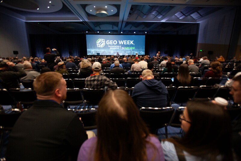
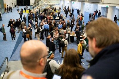
The day of this publishing, February 20, marks one week since over 3,000 geospatial and AEC professionals poured into the Colorado Convention Center in Denver, Colorado for the final day of Geo Week 2024. It was a jam-packed three days full of insightful panels, fascinating case studies and presentations, and energized conversations on the Exhibit Hall floor (which you can see here, thanks to Mike Vorce) that ultimately permeated out into the streets of Denver in the nights following the event.
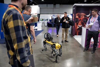
This year’s show included record-breaking attendance and a full floor of exhibitors that included some of the biggest names in the industry standing alongside some of the newest and most exciting organizations. The Geo Week News editorial staff was covering exhibitors, sessions, and keynote presentations throughout the event, and now we’ve had some time to relax and reflect upon everything we saw. Personally, I spent the week running to and from as many sessions as possible while also taking my spare moments to speak with exhibitors and attendees on the show floor. From those experiences, here are the three biggest takeaways I had from this year’s event.
Mobile Mapping
Towards the end of every year, big companies in the industry generally reach out to media outlets to start looking ahead to the following year and what they think can be expected in terms of trends and innovation. These are always some of my favorite conversations, in part because it’s exciting to hear about what experts think is coming down the pipe, but also because there are some established technologies that surprisingly come up as tools that will take a “leap,” so to speak, in usage.
This past year, one tool that was coming up in conversations throughout the year was mobile scanning, or mobile mapping, or however people were choosing to refer to scans that are not taking place with stationary tools, such as those on tripods. It was a little surprising to me given that so much of this technology has been around for some time, but multiple people made those comments to me and sure enough mobile systems were one of the main themes that kept coming up in Denver this year.
This trend manifested in many different ways, with mobile mapping taking different forms. So much of the Exhibit Hall Floor featured different kinds of mobile scanning systems, whether they be on cars or bikes like XenomatiX offers, is modular like Exyn’s new Nexys or Emesent’s offerings, or on drones like WISPR or many of the other systems. You also continued to hear about these different systems coming up in sessions, including the USIBD’s session entirely focused on how different mobile systems compare in a neutral environment.
To me, there are two factors playing into the growing emphasis on mobile scanning techniques. One is that technology is getting better. The systems noted above, as well as many others coming in different forms, offer better accuracy than ever before. They still, of course, are not as powerful and accurate as a terrestrial scanner that is operated on a tripod, but not every job needs that. Additionally, there are more industries and sectors that are taking advantage of scan data, opening up more use cases that call for this technology. Whether it be inspections of roads or other infrastructure, or indoor scans, these tools are becoming a bigger focus in the industry, and that was made more clear in Denver.
Artificial Intelligence
In today’s day and age in the technology space – and really, any industry at this point – it’s inevitable that artificial intelligence is going to dominate most any conversation. That was certainly the case this year at Geo Week, as the general boom in AI is being felt in the geospatial space. That said, it’s generally not the same as what has been infiltrating the mainstream consciousness over the last year-plus.
In that case, we’re talking about generative AI as platforms like ChatGPT and others have started to make their mark on a variety of industries. To be fair, there were some generative AI tools discussed at this year’s event, with some companies adding chat bots to their products, and even one presentation highlighting a point cloud processing application based on generative AI.
However, AI in general is not a new tool in the geospatial space, which has long taken advantage of machine learning and other techniques to help parse large and complex datasets. That said, even in an industry where AI has become established, the recent boom in the broader space is being felt.
AI was talked about everywhere. I could probably count on one hand the number of conversations where it didn’t come up at least once. Right from the beginning in the Day One keynote, AI was mentioned as one of the tools that will help transform the infrastructure industry in the next five to 10 years. Companies are also building more powerful algorithms to do things like feature extraction and model editing faster and more effectively than ever before. We all know there are technology-related trends that generate massive buzz and then deflate before any impact as actually made. That’s still possible for some of the broader generative AI use cases, but looking at the geospatial field, AI has been here, and Geo Week made clear that its presence is only going to grow.
The old and new are coming together
Our first two trends mentioned here are specific tools – or maybe in the case of AI, semi-specific – but maybe the biggest takeaway I had from my week in Denver was more abstract. This year really felt like the merger of new ideas and established workflows showed up in full force. It’s something I’ve also seen and felt at other events, but Geo Week finds itself in a special place to really emphasize these ideals. Geo Week, for those who don’t know, was once three separate events that were brought together four years ago. That brings an interesting mix of, for example, long-time surveyors with those new in the AEC industry who may be taking advantage of new scanning technology.
There is an inevitable bumping of heads when this happens, and that’s something I felt first-hand on the first day of the show. I had the pleasure of moderating a panel focused on the “Democratization of Survey Technologies," looking at some of the new tools that are allowing new people to get into the scanning and measuring space. In the crowd were some long-time surveyors who wanted to hear how this might affect their work, understandably so. For me, the takeaway was that there is room for both, but the side of the new technology needs to understand the value that licensed surveyors provide. (To be fair to the panelists, that was understood on stage.)
It’s not just the traditional surveying space where this is being felt, though. The AEC industry is rapidly changing with new technologies, and that is crucial to keep up with growing demand. However, it’s just as important to take advantage of the knowledge and experience of the older workers on a jobsite. The workflows may change, but the attitudes that have been long developed need to be maintained.
When talking about these “old” industries that are being rapidly filled with new tools and technology, it’s inevitable that parts of the ride will be bumpy. But talking with people of both experience levels at Geo Week 2024, I think both sides recognize the need for the other. The work didn’t end last week to be sure, but getting together in-person certainly helps move the process along.