There’s often talk in the industry about how useful lidar data can be. Sure, you collect the data for a specific purpose – a clash detection or topo – but then, hey, you’ve got it on hand should you have a measurement need or some other question down the line. I’m not sure how often this actually happens, as issues of access to the data and proper storage aren’t always handled expertly, but the theory is good. And this week I actually found a great example of the theory put into action.
Baillie Windfarm Ltd was looking to site a windfarm at Baillie Hill, in County Caithness, Scotland, but was granted planning permission only with a number of conditions. One requirement was for improvement of public access to the Hill of Shebster and Cnoc Freicedain, which are both scheduled ancient monuments; and for improved interpretation of the cairns. Might they be able to do something for the local heritage as they went about their wind evaluations? Well, sure they could.
So, in addition to flying the area with lidar to do a topo study for the purposes of their windfarm development, they also teamed with AOC Archaeology Group (they work with firms to manage historic-site-type hurdles), which helped them put together the very cool site A Window on Caithness’ Past, a public resource that allows people to examine that lidar data and play amateur archaeologist, picking out old burial sites and the like from the terrain models they created.
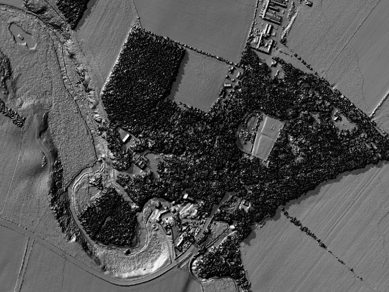
Here’s a sample:
Go ahead and play with it here.
Sure, “access” could mean physical access to the locations. But, in this case, the public is being given digital access, which, in a way, is better. No longer do you actually have to be there to examine the cairns. Pretty cool, if you ask me (though I do see how it’s not the same and the dangerous precedent this could set if digital access were to somehow be equated with physical access. These are public treasures, after all).
The lidar was collected at seven points per meter, which allows for beautiful terrain models at high resolution. You can really zoom in. As they note on the site, you can even pick out individual sheep!
Sure, some of the videos are a little clumsily done – with text that’s hard to read and features alluded to that aren’t necessarily obvious – but it’s a pretty good effort overall. I award high marks for creativity, at the very least.
Hopefully, we’ll see efforts similar to this as lidar is collected for all manner of developments. There could even be possibilities for revenue creation if the sites created by development firms become popular enough to make sponsorship an option.
But that’s crass thinking: Free the data and the people will follow!