

As the market rapidly adopts UAVs to collect remotely sensed data, UAV and mapping practitioners are learning that professional purposely-designed tools are required for professional work.
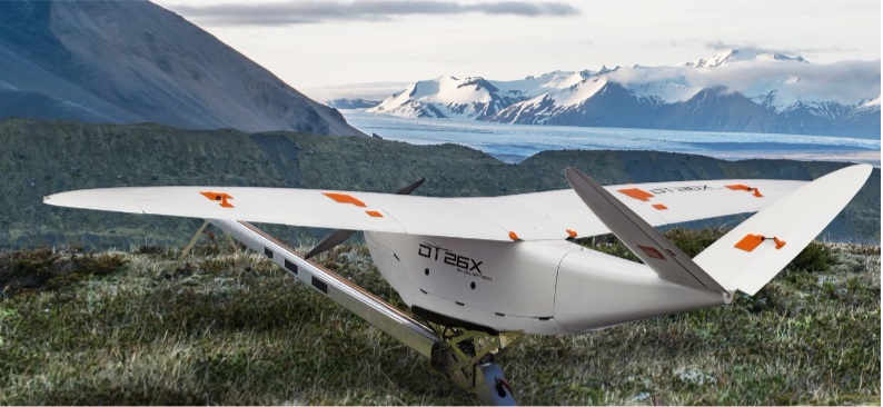
The 2018 edition of the International Lidar Mapping Forum kicked off with many new product announcements that reflect this understanding. Delair’s DT26X Lidar and Microdrones’ mdLIDAR1000 products, in particular, exemplify the technological developments that are raising the standard of professional survey and mapping solutions.
Platform integration
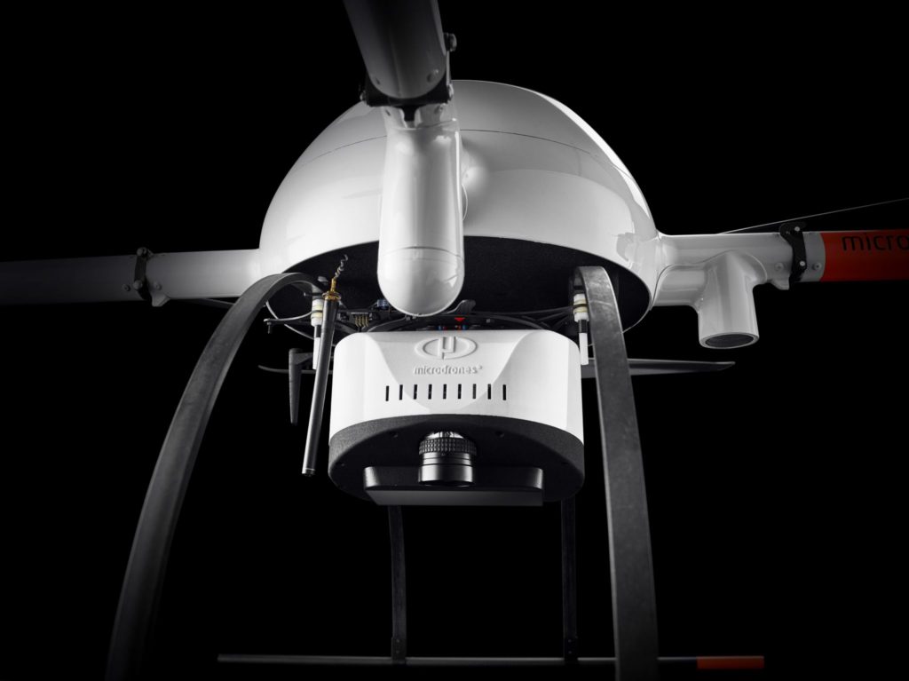
mdLiDAR1000
Both Delair and Microdrones have developed their hardware so that the drone platform and its sensors are one complete system. Their respective fixed-wing and rotary platforms have been designed with professional operations in mind.
In Microdrones’ case, its rotary UAV platforms enclose wires and components to provide protection from the elements. The large props and low RPM motors are designed to provide stable and long operation during extreme weather conditions—as a Canadian familiar with hard winters, I must admit to feeling some comfort in knowing these platforms are developed in Quebec.
Delair hails from Toulouse, France, a country where beyond visual line of site (BVLOS) regulations have been in place for some time. Hence, the firm specializes in producing fixed-wing and long-range commercial platforms.
Here’s where these two vendors raise the bar: The electronic and mechanical integration between sensor payload and UAV platform. Both payloads are custom-designed to work with their paired platform—and that platform only. While this might be restrictive for some, the assumption is that the payload is assembled to the same standards as the platform, and ensures a singular point of delivery and support from the vendor.
Purpose-specific sensors
In an industry where so many payloads have included sensors that were originally designed for applications other than mapping, it is unusual that both of these implementations show effort to miniaturize the overall design concept seen in a traditional manned airborne system.
Instead of a consumer or prosumer camera, both systems utilize industrial-grade camera sensors that have been configured for mapping applications. Instead of a full 360-degree lidar sensor that has been originally designed for autonomous vehicle or mobile mapping applications, both systems utilize lidar sensors that have been designed to focus all lidar points in one direction, on the ground.
These choices lead to far more efficient approaches to mobile mapping. By improving data management through a project, they reduce the extent to which data swath widths need to be edited. Finally, both vendors have implemented the OEM version of Applanix’s AP-15 inertial navigation system to coordinate and directly georeference data from the entire system. This INS is specifically designed to meet the requirements of professional mapping projects (rather than autonomous vehicles, etc.).

mdLiDAR1000 data
Realistic accuracy specifications
Browsing the marketing materials of both vendors, it is refreshing to see more realistic approaches to accuracy requirements. By their nature, lidar systems are often perceived to provide greatest value on engineering or survey-grade projects, where the industry continues to seek 2-inch (or 5cm) survey specifications. In my opinion, this has led end users to insist on such specifications regardless of the use, (or the eventual downsampling) of the data. It has also led vendors to promise or advertise accuracy specifications that push the boundaries of what can realistically be achieved in most situations.
I am very pleased to see Microdrones’ 6cm absolute accuracy specifications (at 40m AGL), and Delair suggesting specifications of “down to 5cm.” Neither vendor promises data that will always fit within the typical 2-inch survey specification.
Are these systems for everyone?
Whether Microdrones and Delair solutions are right for your project is likely to be a function of both operating environment (especially if BLVOS regulation are permitted), and the extent that the price of a complete payload + platform solution impacts your project costs and bottom line.
In turn, the extent that these types of systems will impact those costs will depend upon the proportion of your project roster that is populated with projects where a UAV lidar survey will provide benefit over a photogrammetry-only workflow. These are projects that:
- involve steep topography,
- are on sites covered by dense vegetation, or
- involve a linear-based survey.
In the case of UAV applications, these project types will exploit the efficiencies of direct georeferencing workflows and overcome some of the shortcomings of photogrammetric approaches. In other words, these are application areas where if UAV lidar is used, it is not because it is cheaper means of collecting mapping data, but because it permits you to deliver a product in a location that you may not have been able to deliver otherwise.
Lidar is an exceptional mapping tool and the use of these systems will be driven by many of the professional lidar and surveying and mapping firms that we saw at a gathering such as ILMF. For those that find these types of solutions too expensive, their business will already be satisfying the requirements of customers in other project areas.


