


The fact that we have more 3D imaging systems at our disposal than we know what to do with is a point that is frequently made in this column. There are 3D imaging systems that can model 3” pipes in a densely-packed mechanical room, get information to produce production reports for mines, or even tells us which pieces of equipment might need servicing next. Figuring out what scanning platform is appropriate (or best) and avoiding the platforms that simply leave you frustrated is an incredibly common challenge – especially in most of our ‘day jobs’ as of late.
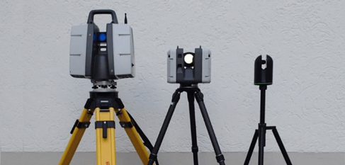
A family of Leica scanners [1] are designed to meet a range of usage and budgetary requirements
The good news: Many of the larger scanning vendors produce different version of their products to meet use and budget requirements, producing more specialized systems that are a better fit for particular applications. The bad news: some scanner manufacturers would love for us to use a scanner in every imaginable situation – and of course, purchase the scanner that’s perfect just for that new task.Added to those challenges is the emotional component: the excitement of any new product release. As users we might even be inclined to “drink the Koolaid” and try to use our “new shiny toys” for everything. Before we get too ahead of ourselves, there are a lot of questions that we should ask ourselves before we decide to try something new.
Productivity is key – but what are the downstream consequences?
Whether it’s the latest lightning-fast terrestrial system, a UAV-mounted lidar system, one of the new handheld scanners or one of the new multi-purpose systems that is designed for use from any of these platforms; the goal is to collect as much data as you can as fast as you can, right? Higher data resolutions means being able to scan on the move, and that means that information can be collected where it may not have been possible previously.
We all know that time in the field is expensive in terms of field crew cost and disruption to any other activities taking place on site. Speed brings larger volume point clouds, whether this is brought through increases in resolution, the area covered by the dataset or both.
But a question often missed is: What are the costs of using that additional data?
Just this last week I was in meetings with IT managers at separate organizations who were expressed their concerns about not only the cost of storage, but also the detrimental effects to network performance when moving large point cloud datasets around. Larger datasets mean longer processing times. No matter how automated your workflow, if there are more records, processing will take longer. Processing time aside, it is unlikely that the point cloud is the end to itself.
Another key question: Does your team have the tools and skills to disseminate this mammoth dataset into the products that are required?
If your team is not equipped to process the data, is important to determine who will be processing it, what the cost of using a 3rd party service provider will be, and how often will you need to use them. For many applications such as production monitoring of stope mining or wood chip production, the objective is to provide regular reporting throughout the process lifecycle. There’s a value in the reporting, but also in reporting the correct information – and those can be different ends.
Given these considerations: Does your team even have the capacity to process the data in time?
For example, when scanning for verification on a construction site, have you considered how the data will be prepared for analysis in the BIM coordination software? And, how it will be done in time to make scheduling decisions before the next building phase?
Then there’s the biggest question: Can you even see what you need in the data?
The beauty of 3D imaging is that no matter what environment you are, it can be digitally recorded and visualized in 3D. There are trade-offs, though. Typically, using lower-grade scanning components or handheld scanners cover a lot of ground quickly, but sometimes miss smaller elements such as narrow or complex pipe structures. Terrestrial systems provide exceptionally higher resolution data but need to be used in a series of static setups. In the following example, traditional cavity monitoring systems collect relatively low-density data, but at a resolution fit-for-purpose for volumetric reporting and fits nicely within CAD and mine planning software. Conversely, the new breed of SLAM-based UAV lidar systems can capture data fast, but at a data density that requires specialist skills and infrastructure to process.
Case Study: Underground Mining
Inspiration for this post came in some part to a piece that I recently wrote for a Canadian geomatics vendor who supplies products and services to the mining industry. In light of many of the technology advances described above, in the context of underground mining there is now often the question of whether specifically designed cavity monitoring systems (CMS) or the new breed of underground UAV systems should be used.
Table 1: A categorization of underground mining tools by Sumac Geomatics[1]
| Survey Technology | Optimal Characteristics and Uses | Potential Drawbacks |
| CMS | Specifically designed for monitoring stope production. | The basic principles of the system’s design data-back decades. |
| Tried and tested; well understood use and workflow. | Not optimal for monitoring long tunnels or drafts. | |
| Easily operated by mine personnel; everyday if needed. | Lower raw point density means that cracks and fissures in cavity wall may not show up in scan. | |
| Other activities in the mine do not need to stop while the CMS is being operated. | Survey setups from more than one drift usually required to access and survey larger stope cavities. | |
| Robust to the challenges of working in a mine environment. | ||
| Data collected is specifically designed for measuring volumetrics. Newer systems include imaging systems for inspection purposes. | ||
| Data imports straight into mine’s existing CAD, planning and project management software. | ||
| UAS | Faster data collection. | The mine usually needs to stop while UAS is in flight. |
| Access obstructed areas. | Pilots need to understand how operational environment differs underground as opposed to over ground. | |
| Damage to the aircraft or its sensor payload is more likely to be catastrophic. | ||
| Need to consider safety of bystanders to the survey. | ||
| Imaging | Images are an easier data source to be interpreted by mine personnel. | Only suitable for structural and environmental inspection as opposed to volumetric production reporting. |
| Lidar | An excellent solution for base-line 3D data collection of all underground infrastructure. | 3rd party service providers frequently required to lend expertise and data. |
| High density point cloud datasets can be used for | Raw point cloud data needs to be post-processed and sub-sampled prior to use in production reporting. | |
| Mine personnel may require specialist software and IT infrastructure to view and manage large point clouds. | ||
| 3rd party operation could mean that survey schedules do not permit survey schedules that are either daily or in line with production. | ||
| Often, simultaneous RGB information is not collected requiring a (separate) imaging data collection method to be used to assist in data interpretation if used for inspection purposes. |
In the summary provided above, each type of tool (CMS, UAV-based imaging, and UAV-based lidar) have strengths in collecting data to support specific activities, for example stope production reporting, headwall inspection or building an initial as-built of the facility. There are overlaps between the capabilities of the systems, but what can have a bigger impact are staffing considerations and IT infrastructure required to process, manage and deliver the information collected for the specific business stream (recall the questions above).
With such a variety of reality capture systems available, we could now be in a position where in many cases there is a realization that from a project and implementation perspective, the cost of implementing a tool is higher than the capital cost of the system itself. This can mean than rather than trying to implement one expensive workflow across all types of project, the tools that we have available to us mean that the most economic approach may be that a range of systems can now be implemented in a complementary basis to glean the right type of information at each stage in an operation’s lifecycle.


