Over the last half-decade or so, we have started to see the effects of climate change turn from theoretical future concerns to present issues in the form of both extreme weather events as well as more subtle changes to weather patterns that affect day-to-day life. With that, every industry is looking to reduce their effects on the planet and scientists from many disciplines are looking for ways to reverse these trends. In the meantime, though, we also need to find ways to adjust to these trends, something that can be greatly helped by geospatial technology, including GIS.
Looking specifically at GIS, earlier this year we looked at how Kaua’i County in Hawaii is utilizing GIS technology from Esri to deal with their own sea level rise. In that case, they used projected sea level rise data, combined with GIS software from Esri, to codify a county law around new construction and renovated buildings.
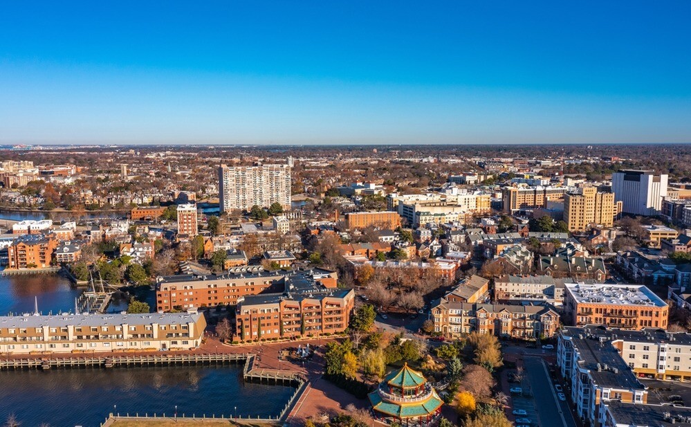
Norfolk, Virginia and other surrounding communities which make up the larger Hampton Roads region is another part of the United States for which climate change – and specifically sea level rise – is top of mind. Like Kaua’i County, they are also utilizing GIS software from Esri, as well as a larger partnership with the company and surrounding institutions like Old Dominion University, to help model sea level rise over the coming decades to help prepare plans of action to keep the community afloat, both literally and metaphorically. Recently, Geo Week News spoke with Dr. George McLeod, director of the Center for Geospatial Science, Education, and Analytics (GeoSEA) at Old Dominion.
In order to get into the ways GIS and other technologies are being used to help protect Norfolk and surrounding communities from sea level rise, it’s helpful to have a little bit of context about the city itself. Norfolk is located in the southeastern part of the commonwealth of Virginia, and is effectively surrounded by water. As McLeod puts it, they are “right at the confluence of the Chesapeake Bay, two rivers – the James and Elizabeth – and the Atlantic Ocean.”
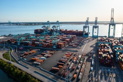
This is combined with it being an important portion of the commonwealth on a number of levels. They not only are home to educational institutions like Old Dominion, but also home to the world’s largest naval base, one of the larger ports on the East Coast, and serve as a popular tourist destination, all of which makes it a crucial region for Virginia.
And for Old Dominion, the problems of sea level rise are an “existential one,” according to McLeod. “Literally, if we don’t figure out ways to mitigate this, the only alternative would be to move campus somewhere else. So we have to work with the city, and that really gives an incentive to scientists and people like myself who live and work here, and intend to stay here, to deploy our expertise in trying to solve this.”
Although climate change can, at times, be a politically charged issue, McLeod notes that this isn’t necessarily the case in a place like Norfolk where sea level rise is so readily apparent. He does say that there still may be debate about the exact causes of some of these issues that are popping up in the community, but “from a practitioner and a problem solver standpoint, that doesn’t matter. The source of the problem doesn’t matter if it’s not something that we can shut off tomorrow.”
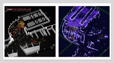
These shifting views and the reality that this was, indeed, an existential problem for the area led to the development of the Coastal Resilience Master Plan, a comprehensive undertaking which is still in progress in the city. This project, which started about a half-decade ago, includes a lot of different facets, part of which involves sea level rise modeling and GIS work, on which McLeod and his team are working. At a high level, the team is using data from the NOAA intermediate high sea level forecast – “not the low and not the high, but somewhere conservatively in the middle,” is how McLeod describes the dataset they used – as map data layer for the years 2040, 2060, and 2080 to forecast impacts of sea level rise throughout the area.
That work was done using Esri’s ArcGIS Pro, and it ultimately led to greater participation from the company with McLeod and his team. He had a previous relationship as well with Keith VanGraafeiland a product engineer with Esri who works on ocean-related projects, and after discussing the work VanGraafeiland expressed an interest on Esri’s part to become involved. “I think we naturally both said this would be a good partnership to further,” McLeod said.
He continued, “From our vantage point, it was about learning how to take advantage of what Esri had to offer in shortening that learning curve, which can be pretty steep when you get into some of these technologies. And i think what we felt we could share with Esri as they were working on developing some similar products and resources was our expertise in coastal flooding and sea level rise.”
VanGraafeiland told Geo Week News, “We’ve been able to just go back and forth on those methods in order to develop new content for Norfolk, and then using Norfolk as our kind of pilot area to figure out, how do we build out one area as much as we can, as a lighthouse type of project.”
Much like any situation involving climate change, the processes around the tools and maps being developed by McLeod, his teams and his partners are ever-evolving as technology continues to change and add more possibilities. They’ve worked to take some 2D datasets and transform them into 3D models for simulation purposes, and more recently they’ve started to view and work with the models in virtual reality. McLeod even mentioned the potential of working with Unity to stream these models even better in virtual environments. He also told Geo Week News about the potential of utilizing drones and photogrammetry to create accurate models of buildings to be placed within the 3D GIS, as well as a number of flood sensors throughout the area to provide more accurate and up-to-date data.
Above all of the technology and innovative tools that are increasingly being implemented into this important work, McLeod highlights the teamwork that goes into making this work. In addition to him, he works with a team within his own office, as well as partners in local government, the team at Esri, NOAA, and NASA. “If we didn’t have those connections,” he says, “we wouldn’t be able to push forward.”
And in terms of what can be done with this information, he’s already seeing it firsthand by virtue of working at a university. “At [Old Dominion], I have the luxury to work with people in all disciplines. We put this in front of health scientists and they say, What about childhood asthma rates resulting from moisture buildup? And then the economist will say, What is the impact on the local economy? The engineers will say, What do we need to build? How will we need to adjust our structural approach? [The work] has a much more broad impact if we can broaden the team out to include all of these disciplines. That’s really important.”
Read more about this work in Norfolk, as well as other coastal flooding work using ArcGIS, here.