

For many of us, one of the defining lessons from science classes in our youth was the introduction of the water cycle. This was one of the first times we were introduced to the idea of everything around us working in concert, and explaining natural phenomena like rain in terms we were able to understand. As one can imagine, specifics around the water cycle have changed – and changed differently in different areas – as a consequence of climate change. The good news is that, thanks to emerging technologies and access to new and better data, we have the tools to better track these changes and adjust accordingly.
This was the subject of a research paper published in Frontiers entitled A Digital Twin of the terrestrial water cycle: a glimpse into the future through high-resolution Earth observations. The paper, published by Dr. Luca Brocca et al, builds off of Destination Earth, an initiative from the European Commission which aims to create a digital simulation, referred to as a “four-dimensional DTE Hydrology datacube,” of Earth via digital twin to understand the effects of climate change. This project is a specific subsection of that, creating a digital twin around the water cycle through which simulations can be run. To learn more about this project, Geo Week News recently spoke with Dr. Brocca about the work, how the digital twin was created, what the current scope is, and the goals for the future.
Dr. Brocca is heavily involved in the hydrology space in Europe as the Director of Research for the National Research Council of Italy with the Research Institute for Geo-Hydrological Protection in Perugia. He tells Geo Week News that the project with the 20-plus-person team started about two-and-a-half years ago when the European Space Agency was starting “smaller activities around some of the components” for the aforementioned Destination Earth initiative. In the abstract for their paper, the group says they are providing “a roadmap for the exploitation of [advances in Earth Observation (EO) satellite technology] in a Digital Twin Earth (DTE) for hydrology.”
This is a model that is still in development, and as such the data being used today isn’t necessarily the full scope of data which will be included in whatever a “final version” this ends up being. For example, Dr. Brocca tells Geo Week News that eventually there will be more ground observation included, whether that be from drones or on the ground in a literal sense. There is some ground observation included already, but for the most part the data collected to create this digital twin for simulations comes from a variety of satellites, the full list of which “would probably be too long to list,” according to Dr. Brocca.
That said, as one can imagine given the roots of this project coming from the European Space Agency there is a substantial amount of data derived from the Sentinel satellite, and Brocca also notes contributions from satellites belonging to EUMETSAT, NOAA, and NASA. More specifically, as outlined in the group’s published paper, the hydrology datacube is created by fusing the following data: Soil moisture, precipitation, evaporation, river discharge, and snow depth.
Dr. Brocca tells Geo Week News that, specifically from Sentinel, the importance comes in high resolution. “Sentinel plays an important role, because from Sentinel we currently can have high-resolution in space, but also in time. This is crucial in hydrology and the water cycle, because precipitation is changing hour by hour, as well as other components, so the temporal evolution is quite important.”
As noted, the purpose of this particular digital twin is to run simulations around the water cycle, particularly as climate change continues to bring more extreme weather events that can alter an area’s water resources. Some examples of what kinds of specific simulations that can be run with this from Dr. Brocca include in agriculture to monitor water being used for irrigation on a day-to-day basis at certain times of years and in certain conditions, and an area’s water resource manager trying to figure out how much water to release. The paper also points to simulations around floods and landslides.
One of the crucial steps for any application like this is to work with potential stakeholders and ensure they are actually able to use it, something Dr. Brocca says has already begun for this project and is one of the most important aspects of this kind of work, along with the high-resolution components.
“The second most important component is the possibility to build a system that is very interactive with the user, because the user shouldn’t just be a scientist or a coder, but also a policymaker or a citizen.”
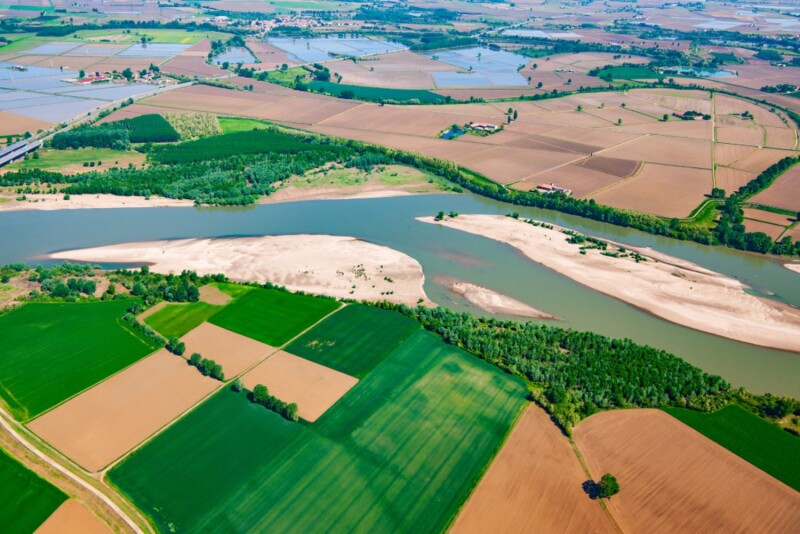
This is still very much a project which is still in progress, and there is still much more that can be addressed moving forward. Part of that is simply the scope. To start off, the team worked on creating a model for the Po River Valley in Italy, and today the work is centered around the Mediterranean Basin. Ultimately, the goal is to expand this project throughout Europe, and eventually beyond into other parts of the world as we.
Dr. Brocca notes tells Geo Week News that from a technical perspective, we have the ability to create these models for other parts of the world as well. However, in order for somebody to do that they would need increased funding and manpower, as well as coordination with other agencies and groups to create larger scale. To that end, the European Space Agency has put out a call for this continuation that is still pending, and for which Dr. Brocca’s team has applied.
Ultimately, he sees a profound impact being generated from this type of tool where users can easily draw from already completed simulations to react to different scenarios.
“This kind of information should be provided in a system like Google Maps,” Dr. Brocca said. “Now, if you want to go from your city to another one, you enter the name of the city, done. Something similar is the long-term vision. It’s to provide easy-to-use information that is based on the huge amount of simulations already done. The key word here is typically: What-if scenario.”


