
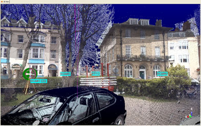
On the site of the Weymouth Pavilion and Ferry Terminal in London, Team Surveys collected data on five large large historic buildings and surrounding car parks.
The next stop for the Olympic Games is London in 2012, and Team Surveys has already begun efforts to ready the sailing event. In April 2008, a three-person survey team hired by developer Howard Holdings used a Trimble GX 3D Scanner to collect elevation data on the site of the Weymouth Pavilion and Ferry Terminal along Weymouth and Portland Harbour. The 16-acre-plus area, which includes the pavilion auditorium rebuilt in 1960, five other large historic buildings, and surrounding car parks and streets, is undergoing redevelopment through the end of the year. The job’s scope included scanning a tree line across the harbor; the heights of the tree line will be compared with new proposed buildings.
Team Surveys had considered conventional technology for the project but settled on the imaging scanner in order to collect as much data as possible without having to return to the site. “In some respects for our deliverable,” says Senior Land Surveyor Stuart Cartwright who did much of the scanning work, “it would have been quicker to use a total station. But it was just in case they [the architect, Barlow Henley]came back and wanted more.” Additionally, Cartwright says, the data-collection time was greatly reduced scan collection took about a week). “I think we would have been there for two or three weeks [with conventional technologies],” he says.
Team Surveys’ experience with scanning technology was fairly limited prior to the Weymouth project. With this project under their hat, Partner Paul Williams, who had established the survey control during a full topographic survey of the site in 2006, says they’ll “consider using it much, much more on other projects because it does save time in the long run, once you’ve got your head around the best way to use it. There is more than one way to use a scanner for each job.”
On this job, the scanner benefitted the team greatly by working in the dark during early-morning and late-evening hours (to avoid rain). Another benefit, according to Williams, was “knowing onsite that you haven’t really missed anything because you can see it right in front of you. We could set it up in front of the building and get the tree canopy behind that was across the river.”
He adds: “The beauty of having the scanner was that we could get a lot of inaccessible points (high ridge points and roof details of buildings) that we probably wouldn’t be able to get with a total station accurately by setting it back further away.”
Included in the 70-plus million elevation points collected for the job were about 5 million for one particular face of the pavilion that contained ornate concrete detail. Position accuracy was generally about 30 meters.
Barlow Henley was reportedly pleased with the results of the two-dimensional AutoCAD models Team Surveys delivered. The architect has the option to request 3D point clouds in the future.
Cartwright says the work at Weymouth was “quite exciting. We got quizzed a lot by the locals. They were interested in what we were doing, what the machine was. We spent quite a few minutes with quite a few people explaining what it was, how it worked and what it was producing.”
When asked how it feels to have contributed to the Olympic Games, Williams candidly remarked, “It’s the only time I’m going to be in the Olympics.”


