
Dynamic survey – 3D laser scanning from a moving platform – has seen a surge of new product introductions this year, most recently at last week’s INTERGEO trade fair in Munich. Aerial LiDAR is not new, of course. Used on fixed-wing aircraft, the technology has been adapted to helicopters for lower-altitude, often more precise surveys. What’s new is a spate of offerings that use the same core technologies – laser scanning, digital photography, inertial measurement and GPS – to scan from a moving car, truck or boat.
Key values of the new mobile ground-based systems are speed, cost and safety. They’re still expensive, no question, but deliver high value in the right situations. Scanning highway corridors from a moving truck can be much more cost-effective than hiring a plane or helicopter, and faster than collecting data from a series of fixed scanner positions – or waiting for good flying weather. It can also be more economical than having a survey crew spend days or weeks in the field. Safety is another driver. On-the-go scanning can reduce and sometimes eliminate lane closures, removing hazards to survey crews and the motoring public – not to mention mitigating the dangers of scanning in war zones or areas of unrest.
For recording as-found conditions of bridges, levees, embankments – data that’s difficult or impossible to capture from land – the ability to scan from a boat or ship is a boon. How else could you readily scan both sides of a breakwater or levee?
Mobile systems are less accurate than fixed-location scanners – on the order of centimeters, not millimeters, depending on conditions – but for many applications that’s fine. Locating road signs to within a few millimeters is often less critical than inventorying all the signs in a corridor quickly.
The business value of traditional airborne LiDAR, already under some pressure from satellite-borne systems above, will be further squeezed by the new mobile ground-based systems below. But we believe land- and water-borne dynamic survey, and the engineering-grade data it yields, open up a whole new range of applications for LiDAR. It wrests the technology out of the hands of planners and conventional GIS professionals, and puts it squarely in the toolboxes of project managers and construction people – think site planning and construction monitoring. The resulting data sets will stress some traditional GIS applications, namely those that are confused by multiple Z values – for users whose main view of data is planimetric, this is a new world. But we think these developments will help LiDAR data evolve from a planning tool to an engineering tool.
Looking ahead, we foresee dynamic survey being used for construction applications – quality control, progress monitoring and documentation, stockpile measurement. Beyond that, as yet unimagined applications are bound to emerge as more surveyors learn what the technology can do.
For service providers, all this spells opportunity. As the lines between airborne LiDAR and terrestrial laser scanning blur, we expect some of the best service providers – from both sides – will follow suit, as their data processing skills will be needed.
Continued
Dynamic survey roundup
Here’s a roundup of new developments in dynamic survey that we saw at INTERGEO and other recent venues.
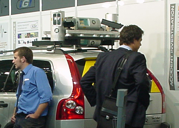
3D Laser Mapping Ltd., a Nottingham, UK-based provider of airborne LiDAR systems, is one of several vendors whose dynamic survey system is based on laser scanner technology OEMed from Riegl. Its exhibit at INTERGEO 2006 featured StreetMapper, a 3D mobile mapping system for scanning roads, buildings and trees from a moving ground vehicle. The system was developed jointly by 3D Laser Mapping and IGI mbH (Kreuztal, Germany). See Figure 1 on previous page. Note the scanners all point to the rear of the vehicle. Anyone who’s driven a motorcycle without a helmet will know why – think bugs in the teeth. StreetMapper can capture up to 40,000 points per second while in motion, according to 3D Laser Mapping; typical positional accuracy is reportedly better than 1m, and point-to point accuracy within the data is 30mm.
Optech Incorporated, a long established provider of solutions for airborne LiDAR and laser bathymetry as well as terrestrial laser scanning, unveiled a Motion Compensation option at INTERGEO that lets its ILRIS-3D terrestrial laser scanner function from a moving platform. Mobile scanning systems typically have two main components: a laser scanner and a position-and-orientation system (POS). POSs in turn have two key parts: a GPS receiver that determines the scanner’s position (location), and an inertial measurement unit (IMU) that detects the scanner’s orientation. Optech’s new Mobile Compensation option lets selected position and orientation systems be connected to ILRIS-3D, allowing it to go mobile.
DEVELO Solutions Inc. (Osaka, Japan) is another innovator we came across at INTERGEO. The company’s Geo Scanner LISA combines laser scanning technology OEMed from Riegl with IMU and GPS technology. The result is a scanner designed to function from most any moving platform – helicopter, boat, motor vehicle, pushcart, crane boom, or even handheld. Used on an airborne platform, range accuracy at 300m altitude is better than +/-5cm vertical and +/-10cm horizontal, according to the company.
Terrapoint, an aerial LiDAR service provider with offices in Ottawa, ON, The Woodlands, TX, and Calgary, AB, is productizing a ground-based mobile scanner that it adapted from its airborne LiDAR technology. Engineering vice president Paul Mrstik reports engineering testing of the new system, called TITAN, has just begun and should take about three weeks. In particular “we want to study how it behaves in certain environments such as going under bridges and through overpasses and obstructed areas,” he explains. Obstruction of the GPS signal is a key difficulty of mobile ground-based LiDAR – thus “we have developed software and GPS/inertial systems to combat the problems of momentary GPS outage.” (Last Friday the Discovery Channel filmed a segment on the new TITAN – watch your local TV listings.)
TITAN is based on development work that began in 2002 when Terrapoint first experimented with modifying its airborne technology to enable mobile LiDAR from a ground vehicle. At the time the company saw no suitable application, but in 2004 following the U.S. invasion of Afghanistan, it was approached by a U.S. engineering company that wanted to survey Afghanistan’s Highway 1 to rebuild it. Unable to locate a suitable helicopter in Afghanistan for an aerial survey, the company resurrected its research project and put it to use scanning Highway 1 from a moving truck. Terrapoint reports it has since used the system on projects for the Quebec Ministry of Transportation and for British Telecom. The prototype system provided about 40 points per square meter at an average accuracy of 3cm to 3.5cm, the company reports. The new TITAN is still being tested but will be at least this accurate if not better, the company reports. (For background see our article Terrestrial 3D Laser Scanning from a Moving Platform.)
Of course developers of airborne LiDAR solutions are not standing still. One company focused on delivering engineering-grade data from helicopter platforms is Tuck Mapping Solutions, Inc., an aerial mapping service provider based in Big Stone Gap, VA. Tuck worked with Riegl USA, Inc. (Orlando, FL) and Trimble business unit Applanix (Richmond Hill, Ontario) to develop a helicopter-based remote sensing and digital photography system it calls eagleeye. Riegl’s LMS-Q240i laser scanner is the LiDAR component, while Applanix supplies the inertial measurement unit and the digital camera. eagleeye is designed for applications that require engineering-grade accuracy – vertical accuracy better than 1 foot and point spacing denser than 1 point per meter – plus high-resolution digital photography for producing orthophotos. Tuck reports the system produces DEMs with 2- to 3-inch vertical accuracy.
Using unmanned aerial vehicles (UAVs) as survey platforms is another novel development. Willem van Spanje, president and CEO of DelftTech BV (Delft, The Netherlands), described to attendees at this week’s IAFSM meeting how his company is developing a robotic helicopter-based system that will incorporate video, photo, LiDAR, infrared and radar sensors. UAVs promise safe capture of live crime scenes, areas of military and civil conflict, hazardous industrial environments and industrial accident scenes. DelftTech expects to have its new system in service in about six months.
Learn more about the latest developments in dynamic survey at SPAR 2007: Capturing and Documenting Existing-Conditions Data for Design, Construction and Operations, March 26-27, Houston, TX. |
The subject will also be addressed in sessions moderated by Spar Point’s Bruce Jenkins next week at the Transportation Research Board 5th International Visualization in Transportation Symposium and Workshop, October 23-26, 2006, Denver, CO.


