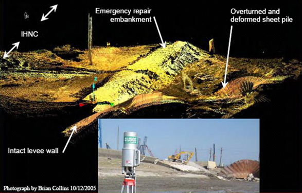
Last Wednesday (November 2) the U.S. Senate Committee on Homeland Security and Governmental Affairs heard testimony based on forensic investigations performed by a National Science Foundation- (NSF-) sponsored team led by the University of California at Berkeley, the American Society of Civil Engineers, the U.S. Army Corps of Engineers and Louisiana State University’s Hurricane Research Center.A Riegl Z210 laser scanner was used by two researchers from the United States Geological Survey (USGS) on October 9-14, 2005 to map 10 sites to measure the magnitude and geometry of the structural and geotechnical deformations associated with the levee failures. I-SiTE software was used to post-process the point cloud data to produce geo-referenced surface models. Chapter 7 of the Preliminary Report on the Performance of the New Orleans Levee Systems in Hurricane Katrina on August 29, 2005 provides details about the scanning work process.
November 8, 2005
Laser Scanning Katrina-Damaged New Orleans Levee Systems