
Airborne LiDAR uses 3D laser scanning to capture topographic and other dimensional data from a fixed- or rotary-wing aircraft in flight. These systems typically depend on a GPS/INS (Global Positioning System/Inertial Navigation System) solution, and in some respects are the easiest way to implement mobile 3D laser scanning. Creating a similar system for ground-based applications has proven more challenging. Attendees at SPAR 2006 learned what one company, Terrapoint, is doing to solve the problem from Paul Mrstik, vice president, engineering, and Dr. Craig Glennie, senior systems engineer.
What’s the crux of the problem? “Where the platform is moving the entire time we’re collecting data,” says Glennie, “we need to know where that aircraft or helicopter or van is located every second it’s capturing data.” How? The position of the laser scanner is determined via GPS, the orientation of the scanner is provided by an IMU (inertial measurement unit), and the scan angles and ranges come from the scanner itself. These data streams are recorded in flight, then combined in post-flight processing to produce a geo-referenced 3D point cloud. “Every hour of flight time, as a rule of thumb, requires two hours of post-processing to produce the final deliverable,” according to Glennie.
Origins: on the ground in Afghanistan
In 2002 Terrapoint developed a prototype to test the concept of mobile LiDAR on a ground vehicle. “Some of our guys did a proof of concept where they essentially took our helicopter system and mounted it on a minivan,” Glennie says. “But nobody could see how to use it, so we put it on the shelf for a couple of years. Then in 2004, after the U.S. invaded Afghanistan, we were approached by a U.S. engineering company that wanted to survey Highway 1 in Afghanistan in order to rebuild it. We looked for two or three weeks, but could not find a suitable helicopter in Afghanistan, and couldn’t find anyone with a suitable helicopter willing to go to Afghanistan. So we resurrected our research project from 2002. We presented it to them. They said, ‘Okay, if you can show us within a month that it works, we’ll accept that as a solution.’ So we resurrected the project, put it together in a month, tested it in Ottawa, and sent it over there.”
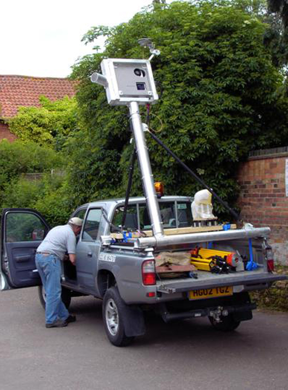
“The idea is to take the helicopter pod – the conventional LiDAR system we were flying airborne – mount it on a truck, and turn it on its side,” says Glennie, thus the company’s name for its new system – SideSwipe. “The assembly is fairly simple: We have the system mounted on the back of an F-150, on a boom that can be lifted up by one person. All the computer equipment is down in the back of the truck. The whole process to get this system set up and running takes ten minutes.”
“The system in this configuration gave us about 40 points per square meter – fairly high-detail information. From that information we were able to produce nearly half-foot contour intervals, so the data was fairly accurate as well.” With Terrapoint’s helicopter-mounted LiDAR system, typical survey density is 2 to 20 points per square meter – considerably lower than terrestrial laser scanners, Glennie notes, but for road design applications, this is usually good enough to produce the engineering deliverables required.
Terrapoint also conducted accuracy tests. It reports accuracy was 3cm to 3.5cm on average. “On hard surfaces, accuracy was down to the 2cm or 2.5cm level,” Glennie reports. “On soft surfaces – in ditches and in grass – it was 4cm to 5cm.”
Continued…
“Boat-dar” – scanning from a floating platform
As a proof of concept, Terrapoint also experimented with scanning from a floating platform. “We created what, for lack of a better name, we call ‘boat-dar,'” says Glennie. “It’s essentially the same pod, in this case mounted on a collapsible rowboat. It was done to test the feasibility of mapping shorelines kinematically from a boat, and also looking at the effects of water and interference patterns on the laser.” One potential use the company can foresee is port-related homeland security applications.
“The net result is that it worked fairly well,” Glennie reports. One reason is that open water is unlikely to have obstructions blocking the line of site to GPS satellites. On the other hand, reflections from the water’s surface caused some problems, which degraded accuracy somewhat.
Mobile scanning benefits: speed, safety, auto-aligned/geo-referenced data
What are the advantages of going mobile with 3D laser scanning? “The first and most obvious benefit is speed of acquisition,” Glennie says. “Driving down the road with a mobile LiDAR system, we can capture data at speeds as high as 75 to 100 km/hr without having to stop. In theory that means you can do hundreds of kilometers of roadway in a day.”
Safety is another big advantage. “Sometimes the areas you’re surveying can be dangerous – say, an open-pit mine, or doing stop-and-go surveys on a highway. If you’re using an airborne platform, you normally don’t have to worry as much about those safety precautions.” With mobile ground-based systems, the advantages for working in hazardous or hostile environments are evident.
“Another advantage is that, because we’re using a navigation solution for the platform, no alignment of the point clouds is necessary,” Glennie adds. “All the data comes out of the post-processing software already geo-referenced and aligned.” In post-processing, data sets are “classified, or ‘de-vegged’ – we use a software package to separate out the ground features from the above-ground features.”
What are the business drivers? In addition to situations such as Afghanistan where operator safety is the driver, says Glennie, “we’re also looking at areas where getting the airborne data may be cost-prohibitive” compared with driving a truck over the same terrain. Adds Mrstik, “A big resistance we’ve found in airborne highway surveys is the cost of the helicopter” – the cost advantage of ground vehicles is evident. Other potential applications, Glennie notes, would include any “where airborne data does not have the level of accuracy you need to do the job.”
Continued…
Current limitations
Of course mobile scanning currently has some limitations – accuracy, point density, field of view, post-processing, GPS shadowing, and the need for an accurate navigation solution.
“First, [with mobile systems], the accuracy is no longer determined by the scanner alone,” Glennie points out. “We also have to consider the accuracy of the navigation solution we’re using to geo-reference the data – that adds somewhat to the error budget.” Another limitation – “the point density is not nearly as high as you would see in a ground-based scanning environment, simply because of the motion of the vehicle.” Terrapoint’s mobile ground-based scanner currently captures 20 to 100 points per square meter, depending on survey requirements.
Vibration of the system can also be a problem. “Normally you can get around that with some gas shocks or fairly rigid bearing mounts,” says Glennie, “but that’s on a case-by-case basis. Sometimes it works, but sometimes vibration, especially on really noisy helicopters or really rough roads, can be a problem.”
Also a constraint is “the limited field of view you have in one pass,” Glennie notes. “Our next-generation system, which should be out in September, will collect a full 360-degree field of view in one pass.”
Another challenge is that the resulting datasets are difficult to process, because most post-processing software is not designed for handling long corridors of side scans when performing vegetation removal. “Most airborne software packages don’t work well with terrestrial-based data in doing this de-vegging,” or discriminating between ground surface and vegetation. “And most terrestrial scanner software packages don’t have the plug-ins or other capability to do this ground-finding routine. So we’ve had to modify the airborne software and write our own to be able to use this data set in such a way as to capture topography.”
“But probably the biggest disadvantage is the need for an accurate navigation solution – this especially becomes a problem when you start working on the ground,” Glennie notes. Why is that? “When you’re in an airplane, you can always see GPS satellites – you’ve always got eight of them in view, and with that many satellites it’s easy to get a good navigation solution,” he explains. “But when you get down on the ground, you start having shadowing from things like vegetation, buildings if you’re in an urban canyon, overpasses and so on. When you lose those lines of sight to GPS satellites, it becomes very hard to maintain an accurate navigation solution.”
Continued…
Futures
What does the future hold? Mrstik and Glennie point to coming technological developments that should enable new applications:
- GPS – new positioning systems and more satellites. “Some of the new satellite positioning systems that the European community and the Russians have been developing will help with the GPS,” Glennie believes.
- INS (inertial navigation system) – ongoing improvements in inertial measurement technology will help deliver more precise attitude data, possibly aided by application of MEMS technology.
- Image coverage and improved LiDAR coverage.
- Additional sensors. “We’re looking at combining images captured with line scanners or full-frame cameras,” Glennie reports, “and adding new sensor types that we haven’t thought of yet.”
- Compass and heading – odometer.
- Replacement or enhancement of GPS using images and/or triangulation LiDAR (for tunneling projects, for example) – “We’re looking at ways to replace the GPS so that we can go underground with these systems.”
Terrapoint expects these advances to benefit three application areas:
- Corridors (for transportation and civil engineering) – highways, railways, power lines, overpasses. “Corridor applications are the ones we’re already working in,” Glennie notes.
- Urban areas – roads, infrastructure, communication and power wires, curbs, intersections. “Once we have the navigation system worked out properly,” says Glennie, “we foresee that urban areas will be our next area – looking at curbs, communication lines, basic infrastructure and asset mapping.”
- Underground/indoors – mines, malls, subways. “The next step after urban areas will be looking at underground and indoor applications.”
About Terrapoint
One of the world’s most experienced providers of airborne LIDAR and digital imaging services for engineering, survey and mapping, Terrapoint (formerly Mosaic Mapping Systems) has completed more than 500 3D laser scanning projects – mostly aerial, but also some ground-based – since becoming involved with the technology in 1995. Terrapoint does considerable research, development and engineering of data capture technology in-house – “we buy very few things right off the shelf,” says Glennie. Currently the company operates seven LIDAR systems – four fixed-wing, high-altitude systems for flying 3000 feet and above, three lower-altitude systems normally mounted on helicopters and flying 100 to 1000 feet above ground, and one system for mobile terrestrial applications. In all, the company has more than 20 years of aerial survey and mapping experience for oil-and-gas/seismic, transportation, land development, powerline/utilities, mining, and environmental/flood applications. A service provider, Terrapoint does not sell its hardware technology but instead uses it to improve its services capability.


