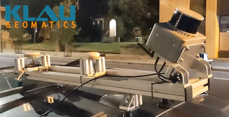
Late last month Klau Geomatics, an Australia-based manufacturer of geospatial hardware and software, announced the release of their latest solution, the Brumby RTK LiDAR. The company describes it as a “mobile mapping system with powerful Edge Compute that generates highly accurate georeferenced point clouds on the fly.”
The mobile mapping system is built to be a highly versatile one, with the ability to be used on a drone, light aircraft, or a mobile laser scanning to be mounted to a vehicle. The system delivers a georeferenced point cloud as the data is being captured, with no post-processing necessary. Under the hood, so to speak, the Brumbly RTK LiDAR integrates dual receiver SPAN INS from NovAtel, running NTRIP RTK or Terrastar-C Pro PPP, with custom code to manage coordinate systems and apply precise geoid models to the trajectory.
The system can be built with scanners from Hesai, Ouster, Livox, Velodyne, or RIEGL sensors. Currently, the model with the Hesai XT32M2X scanner generates data at ranges up to 200 meters, per Klau Geomatics, with the exact range depending on reflectivity. Additionally, while the Brumby does not require post processing of the data, all of it is stored on the Brumby, including GNSS, IMU, lidar, calibration files, and metadata, so it is possible if a user wants to take advantage. They point to software from Hexagon, Agisoft, and Blue Marble Geographics as options for this post processing.
In their release of the news, Klau Geomatics highlights the fact that Brumby is not a SLAM system, but is geo-referenced “so it has real-world coordinates.” This helps ensure better change detection over time, as exact coordinates can be compared between multiple scans with the only variable changing between data collections is time. They point to asset managers as well as those in the mining, military, and emergency services spaces as sectors that could benefit from the technology.
This continues along with a trend that we talked about just yesterday around mobile mapping. The established technology seems to be seeing a bit of a boom with a bevy of products released in this space coming to the market over the last six to twelve months. Taking trends a step further, we are starting to see more of these “customizable” options, with this Brumby RTK LiDAR system able to be used with different techniques, ranging from crewed aircraft to UAVs to typical ground vehicles.
Particularly for end users who are capturing data for large and/or complex areas, be it complicated road systems or mines or anything else along those lines, being able to have that option within a single system is massively important so one doesn’t have to buy multiple systems. That extra level of customization in regards to not having to post process, but still having the option to do so, adds extra value as well.
“The LiDAR industry is currently like surveying was ‘pre-RTK’. For those of you who can remember surveying before RTK (a bit like asking if you remember a world before the internet), you’ll understand where I’m coming from. This is all about to change,” said Rob Klau, Director of Klau Geomatics in a statement.
Klau Geomatics shared a video of a recent capture with the Brumby RTK LiDAR, shown below.