New Sense & Avoid technology via LIDAR could make unmanned aircraft systems more available to civilian customers
As regular SPAR readers will know, aerial surveying using laser scanning or photogrammetry are established means of identifying potential archaeological sites, forest cover or the solar energy potential of rooftops, among other things.
But, a new study from scientists at the Carnegie Institution for Science and South Africa’s University of Pretoria reveals the technologies are just as adept at advancing our knowledge of natural history as it is providing new insights into ancient history.
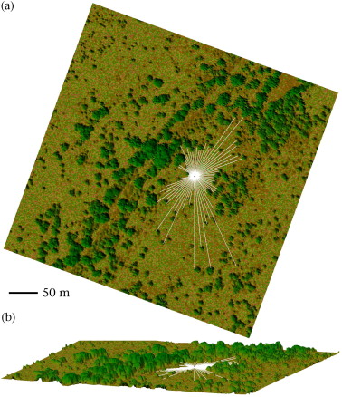
Scientists Scott Loarie, Greg Asner (both from Carnegie) and Craig Tambling (University of Pretoria) mounted a LIDAR scanner aboard an airplane used by the Carnegie Airborne Observatory (CAO) to map the savannah vegetation of South Africa’s famous Kruger National Park, according to the study, published in the journal Animal Behaviour.
The point clouds created by the scanner were converted to 3D maps, where GPS data about the predatory behaviour of seven of the park’s lions was added to give a clear picture of the difference in lines-of-sight between the lions’ killing and resting places.
Analysis of the digital terrain models and behavioural data revealed a clear difference in nocturnal hunting habits between male and female lions, with the male lions tending to hunt in dense vegetation, while the female of the species preferred to hunt in areas with large view-shields, i.e. open grassy savannahs.
The study’s results help explain how male lions use ambush behaviour to rival females’ hunting success.
If confirmed by further studies, these findings could have important lessons for management of the Kruger National Park and other game reserves in Africa.
“By strongly linking male lion hunting behavior to dense vegetation, this study suggests that changes to vegetation structure, such as through fire management, could greatly alter the balance of predators and prey,” said Loarie.
Staying airborne
Of course, the big buzz in the airborne scanning sector, at the moment, is all about unmanned aerial vehicles (UAVs), which are using laser scanners not just to record what’s on the ground, but to avoid mid-air collisions between drones and other aerial traffic or obstacles, in the same way LIDAR is being used back on terra firma to ensure safe passage of driverless (or ‘piloted driving’) cars.
In fact, laser scanning of this kind has quite a long history in the fairly short-lived UAV sector. Penzberg, Germany-based company EMT, Europe’s leading manufacturer of tactical unmanned aircraft system (TUAS), which has supplied some 750 drones to customers over the past 15 years, began test flights of a ‘Sense & Avoid’ system way back in 2005.
Now, EMT has launched a second generation version of the technology, developed in partnership with local engineering firm Spies and the German government, for its LUNA TUAS and Museco helicopter drone.
“EMT and Spies are both delighted to be promoting Sense & Avoid technology via LIDAR and transponder – after all, this enables our unmanned aircraft system to finally take part in general air traffic [conditions]. This makes advantages such as easily affordable purchasing and operational costs of unmanned aircraft systems more available to civilian customers,” said Sascha Lang, EMT’s head of business development, in announcing the launch.