
Kaarta is known as much for its line of handheld 3D-mapping devices as it is for the SLAM engine that powers them. The engine’s primary claims to fame have been its fast processing, real-time on-device display of results, and minimal drift. It’s time to add another feature to that list: improved photorealism.
This week, the company announced Kaarta Reality Layer, which adds integrated colorization capabilities, making it possible to “quickly capture and process just the level of color detail needed” for built environment applications throughout a structure’s lifecycle.
How it works
The processing is simple and quick. Kaarta tells SPAR3D that the Contour handheld scanning device captures imagery as it goes, and the user simply presses a button on Contour to initiate an automated process that creates the Reality Layer. If the user does not require ultra-high resolution, the whole colorization process can be performed in the field in “approximately the same amount of time it takes to scan,” or a matter of minutes.
For users who require photorealistic levels of detail, Reality Layer automatically processes the point cloud to create surface models over which it drapes high-res color imagery. Again, all of this is performed on the handheld device. “Reality Layer reveals features such as surface textures and colors, locations of electrical, plumbing, HVAC and other features, or even details as fine as the text on signage or labeling.”
Transition from point cloud to surface mesh to color point cloud to photorealistic 3D model.
Why this is an innovation
Kaarta explained that accurate, realistic colorization has been a challenge in the past for handheld scanning devices. That’s because, when using a handheld scanner, “each tiny point cloud of a few milliseconds of data collection is immediately added to the entire point cloud, but the overall combination may ‘drift’ from reality.” Such drift makes it difficult to determine exactly where the scanner was located and where it was pointing at the moment when the photo was required—information necessary for matching the scan and the photo.
“Because our native capture tends to be complete and accurate,” Kaarta says, “our location information for the sensors is also very accurate, enabling us to then position the individual photos correctly in the point cloud rapidly and accurately, yielding a scene with both high dimensional fidelity and very high visual fidelity.”
What this does for you
In the past, it has been common to record information about space using different kinds of data—drawings, scans, photos—all captured by different devices, different people, and over different timeframes. Naturally, it can be difficult to line these up for a complete, unified picture. Kaarta promises to do all that work in “one product, operated by one person in a single pass.”
Benefits of this development include further adoption of BIM practices, cutting-edge mixed reality applications, reduced call-backs to the site, and lower costs for capturing spaces.
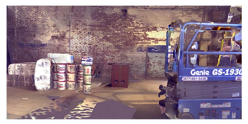
Fasttac recently used a Kaarta Contour to scan the boiler rooms of a medical center, and CEO Ray Steeb says that the device made it very easy to capture spaces without up-to-date drawings. The key benefits, he said, is that Fasttac can use the scans “right away without having to model” and the new Reality Layer makes it “even easier for users to get a visual ID on any given area.”
Reality Layer is now included on all new Contour devices, and available as a free software upgrade for current Contour users. Kaarta says that integration for other devices is on its way.


