
At the beginning of the annual HxGN:Live conference, Leica Geosystems announced their first unmanned ground vehicle (UGV), the Pegasus:Multiscope. The system is intended for off-road use in surveying, security, and monitoring applications.
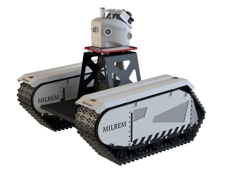
Leica developed the system in partnership with Milrem AS, an Estonia-based unmanned technology company specializing in military defense clients. The Pegasus:Multiscope mounts Leica’s Pegasus:Two mobile mapping system with the Milrem’s modular Multiscope UGV.
Pegasus:Multiscope offers users all of the sensor options of the Pegasus:Two mobile mapping system with the added benefits of a versatile unmanned ground system capable of moving over many difficult terrains including mud, sand, and snow. It has a top speed of 15-22mph, a zero turning radius, and the ability to drive up a 45° incline.
It’s worth noting why a customer might use an unmanned ground vehicle over an unmanned aerial vehicle. Ground vehicles are subject to fewer regulations and boast a much longer effective time, given their ability to carry a larger payload and store more energy. The Pegasus:Multiscope includes diesel generators that are rated for up to 10 hours of use.
The companies are marketing the device as “ideal for industries that can gain from automating processes to eliminate physical risk, such as surveying challenging terrain for civil engineering infrastructure projects, agriculture, or in hazardous areas such as nuclear power stations or areas of intense conflict.”
For civil engineering applications, the system can easily traverse areas such as “riverbanks when surveying for dam construction,” increasing overall safety by keeping field personnel from dangerous areas.
Pegasus:Multiscope can also be used in farming applications, where Leica says that the system “offers the potential of real-time essential data for improved productivity.”
“We live in an ever-changing world where difficult terrain can prohibit our abilities to advance,” said Stuart Woods, VP of Leica Geosystems’ Geospatial Solutions Division in an official statement. “We can now overcome these challenges with the Pegasus:Multiscope, enabling movie mapping to be carried out in places unreachable by traditional vehicles.”
Leica has not announced a price for the system, or its date of availability, but SPAR will report as soon as more information becomes available.


