The information you submit will be stored and used to communicate with you about your interest in Geo Week. To understand more about how we use and store information, please refer to our privacy policy.
The information you submit will be stored and used to communicate with you about your interest in Geo Week. To understand more about how we use and store information, please refer to our privacy policy.
The NavVis IndoorViewer has been the focus of development for NavVis this, with a major update to the indoor spatial intelligence software launched earlier this year. The latest announcement from NavVis today brings the IndoorViewer into the cloud, providing more options for accessing and processing scanning projects to its users.
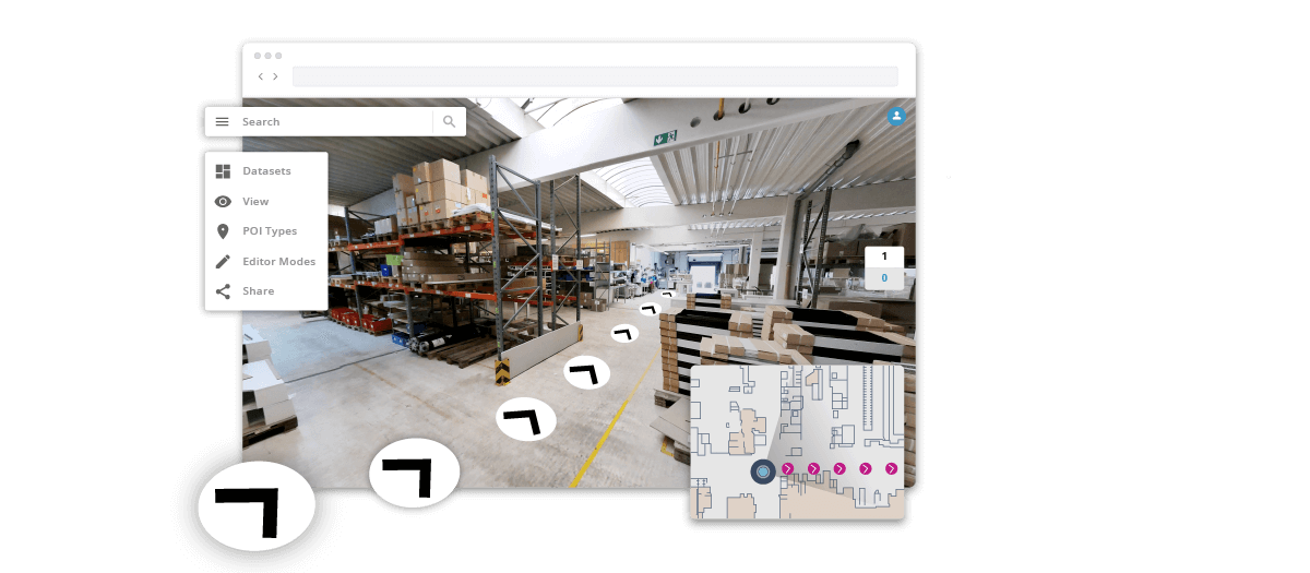
NavVis IndoorViewer is a web-based application that transforms data captured by laser scanners into immersive 3D buildings with a user-friendly interface. With a few clicks, scan data is automatically structured into a basic model of the building and can be displayed as realistic 360° walkthroughs, point clouds and customizable floorplans. Users can then move around scanned spaces as if they are on site and use the interactive functionality to add, search for and route to geo-tagged information, as well as take accurate measurements.
NavVis Cloud is a new cloud-based platform that provides Software-as-a-Services (Saas) access to IndoorViewer. With NavVis cloud, laser scanning professionals can more easily share and access the immersive scans and floor plans created in NavVis software. Combining the user-friendly user interface and functionality of IndoorViewer with the cloud will allow for more stakeholders to interpret and interact with scan data.
NavVis IndoorViewer has focused on adding value for laser scanning professionals, particularly those who want to use of point clouds beyond BIM models and building plans, and to share them with a wider range of stakeholders. This is particularly relevant for stakeholders working on complex projects or properties, such as manufacturing facilities and construction sites, who can now use NavVis IndoorViewer to access and collaborate on the scan data at the office, job site, and even in transit.
According to Georg Schroth, NavVis CTO, NavVis Cloud is the next logical step for professionals who want to engage stakeholders.
“Now even more users will be able to receive NavVis IndoorViewer as part of scan projects. With NavVis Cloud, our flagship software is available on demand, making it easy for laser scanning professionals to upload point cloud files and create and publish as many NavVis IndoorViewer instances as needed.”
Although NavVis IndoorViewer was originally developed to display data captured by the NavVis M6 IMMS, it now includes a feature that brings the fully immersive experience to terrestrial laser scanners. Structured E57 point cloud files are automatically converted into realistic 360° walkthroughs when uploaded to NavVis IndoorViewer. With a NavVis Cloud account, laser scanning professionals can access this feature with pay-as-you-go pricing and deliver NavVis IndoorViewer instances with as many scan projects as needed.
Carla Lauter is the editor of Geo Week News, creating and curating content and newsletters in support of Geo Week. Before joining Diversified Communications, Carla spent 10 years on NASA and National Science Foundation funded projects focusing on Earth science and communication. She has worked on web-based outreach and online interactives for NASA Earth Science, including products for satellite missions measuring sea level, salinity and hyperspectral ocean color.