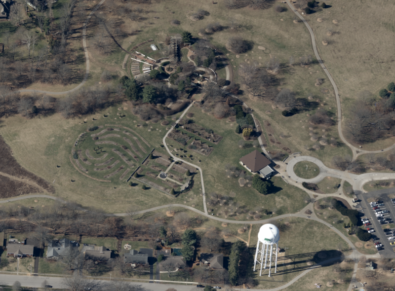
NV5, the world’s leading provider of geospatial software and services, announced that it recently completed the largest single oblique imagery collection in the United States for the Commonwealth of Kentucky. Spanning 40,660 square miles and offering rich detail at three-inch scale, the project is part of the KyFromAbove initiative, which makes high-resolution imagery and geospatial data publicly available.
“Working with NV5, we are democratizing access to information that has a real bearing on each Kentuckian’s quality of life. This new imagery will enhance public safety, economic development, infrastructure planning, property assessment and other critical efforts across every corner of the Commonwealth,” said Kent Anness, Kentucky’s geographic information officer. “Some Kentucky counties can afford to acquire their own oblique imagery, but many don’t have the resources to do so. This important investment will pay vast dividends by reducing duplicative spending and providing a seamless basemap for everyone. As a result, all communities, regardless of their population or tax base, will have access to the same level of data. Open access to the oblique imagery will finally level the playing field.”
Kentucky is the first state to make such detailed oblique imagery available publicly. Through the KyFromAbove portal, everyone has free access to this information, wherever and whenever they need it. Oblique imagery provides high-resolution, multi-angle views of landscapes, crucial for a variety of applications that span traditional county borders. Government agencies can use oblique imagery for tax assessments, urban planning, infrastructure development, disaster management, enhancing situational awareness for first responders, improving land use and managing public lands. The imagery is openly available to the public and commercial entities, such as real estate firms examining properties, insurance companies assessing damage, solar companies determining viability of putting panels on homes and businesses, or a hiker who wants to explore a state park trail system.
Setting the Standard for Edge-to-Edge Oblique Imagery
Kentucky selected NV5 to undertake this unprecedented project in 2022. To ensure the best images possible, Kentucky specified that all collections must take place in near-perfect conditions: no leaves on trees, no cloud cover, no snow on the ground or flooding, with a sun angle greater than 30 degrees. NV5 leveraged top-of-the-line Vexcel Osprey 4.1 sensor technology, which acquires photogrammetry-grade nadir (PAN, RGB and NIR) and three-band (RGB) images in the four cardinal directions to produce oblique imagery at a highly detailed three-inch scale.
Starting in Eastern Kentucky, the first phase of oblique imagery was captured in Fall 2022, with additional phases proceeding to the west completed during optimal conditions through April 2024. Currently oblique imagery from Eastern Kentucky is available via KyFromAbove, with the remainder of the state expected to be made public by Fall 2024.
“Kentucky is leading the charge in edge-to-edge oblique imagery acquisition and setting the standards for other jurisdictions seeking to do similar projects in the future,” said Chris Holder, senior project manager for NV5. “Such a cohesive collection will save cities and counties tens of thousands of dollars a year, while promoting fact-based decision making on many levels, which will have a positive economic impact throughout the Commonwealth.”
Source: NV5