

In the fast-moving world of 3D imaging, one tool can be usurped by another, practically in a moment. Technology is advancing so rapidly that tasks are being redefined, and a task that might have recently been done by a drone can be done with a different 3D image-capturing system.
Now, laser-scanning professionals can use such technology to convert point clouds into interactive, fully immersive 3D buildings online, and stored in the Cloud. NavVis recently launched the NavVis Cloud, a new cloud-based platform that gives laser scanning pros access to NavVis IndoorViewer as a Software-as-a-Service solution that transforms data captured by scanners into 3D buildings.
The new NavVis Cloud enables users to produce 3D buildings in any scan project, by using point cloud files from laser scanners and the NavVis M6 Indoor Mobile Mapping system.
It’s just the latest development in the German tech startup. A year ago, NavVis announced the release of its latest indoor mobile mapping system, the M6. That cart-based system includes four laser scanners, six cameras for capturing 360° imagery, and sensors for tracking Bluetooth beacons, WiFi signals and magnetic field data.
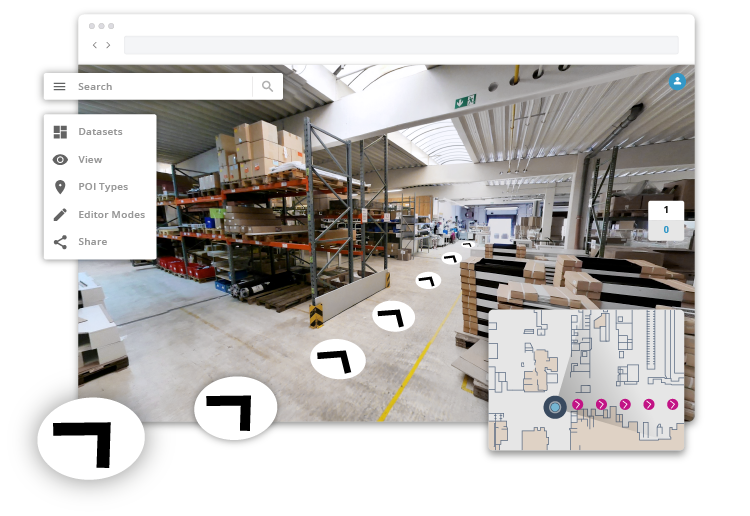
The latest NavVis enhancement means that with just a few clicks of a computer mouse, scan data is automatically structured into a basic model of the building and shown as 3D walkthroughs, point clouds and customizable floorplans. Users can navigate through scanned spaces as if onsite. They also can use the tool to take accurate measurements, and add, search for and route to geo-tagged data.
“We have been getting a lot of positive feedback on how much this has improved efficiency for project stakeholders,” says Georg Schroth, NavVis CTO. “Now even more users will be able to receive NavVis IndoorViewer as part of scan projects. With NavVis Cloud, our flagship software is available on demand, making it easy for laser scanning professionals to upload point cloud files and create and publish as many NavVis IndoorViewer instances as needed.”
The NavVis system is being used to streamline operations in various industries, company officials say. Manufacturing is just one of their markets.
“One of the most common ways NavVis IndoorViewer is being used is to create digital twins of factories. This is especially popular among automotive manufacturers and was actually pioneered by a major German automotive manufacturer,” says NavVis spokeswoman Viktoria Langley.
The fast-adopting world of Building Information Modeling (BIM) users also has become fertile ground for NavVis technology, which has been developed to complement BIM and architecture engineering and construction (AEC) tools.
“NavVis IndoorViewer is often used by AEC professionals for verification during as-built BIM modeling. There is a free add-in for Autodesk Revit that has been specifically developed for this purpose,” Langley says.
The NavVis technology is compatible with most standard point cloud file formats, which means any building captured by a 3D laser scanner can be uploaded to the NavVis IndoorViewer.
“Due to customer demand, we developed new features to support third-party data in NavVis IndoorViewer. At the end of last year, we introduced a new feature to make NavVis IndoorViewer fully compatible with static laser scanners. If a structured E57 file is uploaded, the software automatically converts it into an immersive 360 walkthrough,” Langley says.
When it comes to mapping technologies, accessibility may be the most important characteristic of a mapping tool. Users must find the tool easy to intuit and simple to use.
NavVis IndoorViewer was built around the same functionality as outdoor map products, company officials say.
“That means anyone who has used Google Street View can use it. Our software combines realistic 360° walkthroughs, point clouds and customizable floorplans with a user-friendly interface and interactive features such as a measurement tool, points of interest, search and routing functions. By making scan data intuitive and accessible, NavVis IndoorViewer offers a collaborative platform for every project stakeholder who needs the valuable real-world context that 3D laser scanning captures,” Landley says.


