

NavVis IndoorViewer is a web-based 3D building visualization software that displays point clouds, 360° panoramic images and floorplans as realistic, fully immersive digital buildings. The latest release of NavVis IndoorViewer 3D building visualization software features a new measurement tool, that was first introduced with the launch of NavVis IndoorViewer to enable distance measurements in a web browser. The redesigned version of NavVis IndoorViewer enhances its usability and accuracy and offers distance measurements for point clouds in a web browser. Most importantly, these measurements can be done remotely, thanks to browser-based access that saves the user the time they would have spent traveling to the site.
Knowing how important this tool is for users, a more accurate and user-friendly tool was developed: the point clouds uploaded to NavVis IndoorViewer and converted in realistic digital buildings now include the measurement tool as a standard feature. A ruler icon in the menu bar lets users get started and take measurements that can be saved to individual accounts and revisited at any time. The interface was designed to be intuitive so anybody can use it to take in-browser measurements. The magnifying icon can be used to pick the exact point cloud point while in the realistic 3D view, only the point cloud points of a small area are shown while the surroundings remain displayed as the realistic view.
Overcoming accuracy and usability problems
The latest version of NavVis IndoorViewer (v2.6) has been redesigned to overcome two of the biggest problems with virtual measurement tools: accuracy and usability. While point cloud measurements are quite accurate, the software tools used to take point cloud measurements are often not accessible or even usable for a wide range of building stakeholders who lack the expertise in working with point clouds. Also, users who do work with point clouds find it painful to find the right point to measure. More user-friendly tools that use images or even meshes are usually not reliable enough to produce accurate results, because it is impossible to know if the image matches up with the point cloud point.
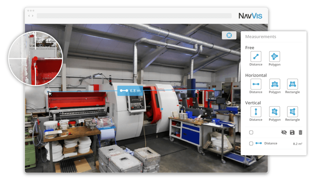
The patent-pending magnifying feature in NavVis IndoorViewer 2.6 lets users take precise point cloud measurements in the realistic 360° view
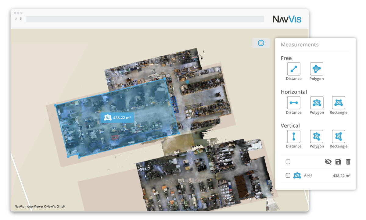
To overcome both of these challenges, the measurement tool in NavVis IndoorViewer now includes a magnifying feature in the realistic 360° view that provides a behind-the-scenes look at the point cloud. This lets users pick the exact point cloud point while benefiting from the intuitive interface of the fully immersive walkthrough. Measurements can also be taken in the HD colored floorplans that appear in the 2D map view. These detailed floorplans are both easy to interpret and highly accurate because they have been generated using point clouds.
In addition to making strides in the accuracy of remote measurements, the interface of the tool has also been fully redesigned. In addition to the new magnifying feature that makes it possible to view sections of the point cloud in the realistic panorama mode, NavVis has introduced a slider function that lets the user toggle between 2D and 3D mode, taking measurements side-by-side. So on the one hand, this function provides an overview of the entire building, which makes it easier to locate the asset or area that is to be measured. And at the same time, the location selected on the floorplan appears in the realistic 360° view, making it possible to virtually walk through the area being measured or inspect the asset, similar to how a measurement would be taken on site.
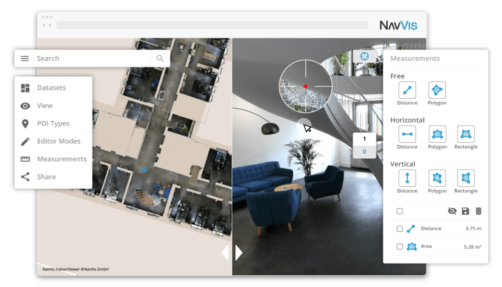
The slider function in the NavVis IndoorViewer measurement tool lets users simultaneously view the building in 2D and 3D
E57 point cloud support
Finally, the release of NavVis IndoorViewer 2.6 introduces new feature support for e57 point cloud files captured by static scanners. NavVis IndoorViewer was originally developed to visualize the data captured by its own hardware devices in an intuitive and accessible way. In 2017, NavVis introduced a feature that made it possible to upload point clouds from third-party devices. While this feature was very well received, it was limited to the point cloud view in NavVis IndoorViewer. While many end-users prefer the realistic panorama view in NavVis IndoorViewer, some scanners capture images that are not dense enough to provide the fully immersive 3D walkthrough that lets users move through a building in NavVis IndoorViewer as if they were on site.
To overcome this, NavVis developed algorithms that automatically extract any available images and reconstruct missing ones using colored points clouds. Although all e57 point cloud files can be uploaded to NavVis IndoorViewer, this feature is only available for those files post-processed as structured e57 files, which is only possible with static scanners. E57 is the most common type of point cloud file, so NavVis generally aims to support this file type when releasing new point cloud features. The company initially released the point cloud download feature in NavVis IndoorViewer 2.5 for e57 files, but in the latest release, the options of saving downloaded point cloud files to .las and .ply have been extended.


