
EMAPS helps deter nuclear weapon threat
Engineers at the Johns Hopkins University Applied Physics Lab (APL) have developed a portable mapping system – carried in a backpack – that can be used to automatically create annotated physical maps of locations where GPS is not available, such as in underground areas and on ships.
The Enhanced Mapping and Positioning System (EMAPS) captures a floor-plan-style map of the area traversed, as well as 360-degree photos and sensor readings of that area using a combination of lasers and sensors. The system improves upon algorithms once developed for robots, which are not practical for all environments, and has a built-in allowance for normal human movement, like walking.
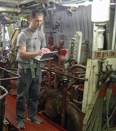
Using lidar sensors, EMAPS works while operators walk through an area carrying the unit in a backpack. Designed mainly to detect and map environmental threats on ships and in other tough-to-get-to locations, EMAPS’ novel algorithms also associate critical environmental data, such as radiation or radio frequency signal levels, with map locations.
The basic EMAPS unit is an approximately six-inch cube that weighs less than four pounds (smaller than a brick), and includes a 270-degree laser scanner that measures the distances to walls and features in the environment.
“EMAPS virtually takes pictures with every step,” said Jason Stipes of the Force Projection Department. “Using this technology, we can map almost every nook and cranny of targeted locations, capture that intelligence, and store it. Sensors can also detect threats, such as radiation or chemicals, and include them in our map.”
A second laser scanner is available to allow 3D data collection, while an inertial sensor measures the roll, pitch, and yaw of the system to compensate for steps taken by the user.
In addition, a removable camera system can be used to capture omnidirectional images along the walker’s path. A GPS receiver can be connected to EMAPS to allow for georegistration of the data, and an onboard computer stores and processes data in real time.
Stipes said EMAPS has collected more than 100 hours of mapping data from a wide array of GPS-denied environments, including ships, underground storage facilities, Army training areas, and buildings such as the Smithsonian Natural History Museum. The maps include paths that are several miles long, in environments ranging from office buildings to complex engine rooms of ships at sea.
EMAPS was produced for the Defense Threat Reduction Agency (DTRA), which consolidates a variety of U.S. Defense Department functions to deal more effectively with the threats posed by nuclear, chemical, or biological weapons.
“The EMAPS software addresses a number of challenges using specially developed algorithms,” said Stipes. “Working with DTRA, APL engineers have created software to efficiently map data without boundaries while using a fixed amount of computer memory. And, while previous algorithms fail in open areas and long, smooth hallways, we have been able to design algorithms to map these challenging environments.”


