
Pix4D, producers of photogrammetric software for UAVs, have added another product to the lineup: Pix4Dmapper Mesh. The application automatically converts data captured by a consumer drone into 3D models. It is capable of handling still photographs taken by the 3DR Solo, DJI Phantom 2 and 3, DJI Inspire 1, and the Parrot Bebop, as video taken by action cameras such as the GoPro.
The company is positioning the Mesh application to appeal to consumers and new kinds of professionals as well as the mining, precision agriculture, construction, and emergency response industries served by the rest of the Pix4DMapper line.
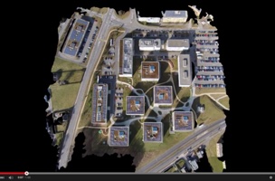
“Want to create a 3D model of your property and publish it online?” asks Pix4D in a list of possible use cases for their new software. “Map your adventure and create a 3D video animation? Need to inspect roofs, house extensions or solar installations? Produce a 3D model of architectural or landscaping project to share with clients? Create digital art and 3D content for gaming?”
Appropriately, Mesh includes many of the same features that can be found in Pix4D’s other applications. When used in concert with the Pix4Dmapper capture app, the solution allows for cloud storage and processing, as well as quick 3D preview, which generates a preview of the 3D model automatically and delivers it to the user’s cell phone. Other features include assisted project creation, fully automated processing, point cloud and mesh navigation modes, annotation, editing, video, and multiple output options.


