


Trimble has been hard at work developing and testing a new augmented reality system; recently performing live demonstrations at several conferences, including the recent 2019 Esri User Conference in early July. The anticipated product, called Trimble SiteVision, combines geospatial referencing with 3D visualization to provide context to building models.
Recent advances in augmented and mixed reality (AR/MR) have often focused on indoor spaces, but have yet to bridge the gap between a site plan and the outside world. Trimble hopes to solve this by leveraging its existing high-accuracy positioning technology to create a better solution for visualizing geospatial data in situ. Trimble SiteVision will accomplish this through the joint application of two technologies: the Trimble Catalyst soft GNSS receiver and Google ARCore technology.
Stephanie Michaud, Strategic Marketing Manager for Geospatial Field Solutions at Trimble, described this combination as incredibly powerful for going from design to reality.
SiteVision allows for the viewing of models in their true positions in the field.
“Leveraging the tools with Google ARCore and our high-accuracy Catalyst antenna, we are able to create a product that really gives you the highest accuracy to visualize and collaborate on your models in real time throughout the design process in the field.”
SiteVision allows users and clients to view new designs, reveal existing hidden infrastructure (like underground utilities) or visualize how new landscapes may change over time, without having to interpret multiple drawings and maps. SiteVision will allow for this information to be viewed at life scale, and in the context of its surroundings. Michaud knows this is a crucial area where efficiency can be improved, especially compared to today’s paper and model-based workflows.
“Right now, we might be measuring the field with a high-accuracy device, but there are limited ways to tie that into the paper plan or the model in the office.”
To use SiteVision for a project, a designer or architect would use a 3D design tool (e.g., a BIM design platform or AutoCAD), and then export that into the Trimble Connect platform. From there, it can be instantly shared to users who may need to access it, such as a utility surveyor or building construction site crews.
When they open SiteVision, they can then download the model to their smartphone, and it will automatically be “placed” in its location driven by embedded GNSS coordinates. Where GNSS is unavailable, a “measure-to” mode can be used to place the model manually. Once it is there, the model can be walked through, examined, and then modified. If there are clashes and conflicts, they can be captured in both the real and digital realm with photographs and measurements taken with the device. Staff back in the design office could then get that information and begin revisions with no travel time and with more clarity and better communication.
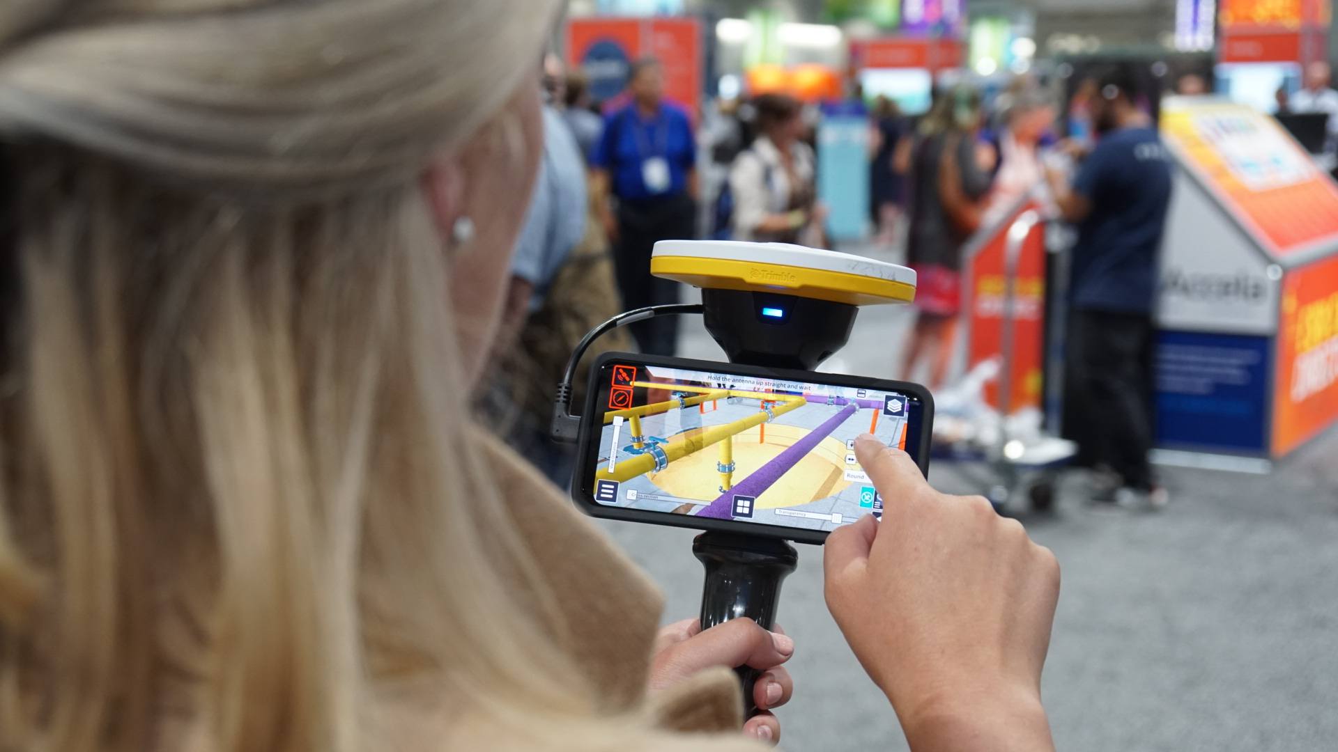
A demonstration of SiteVision at the Esri User Conference, 2019.
Trimble has leveraged the Android interface for SiteVision so the solution works with existing geospatial tools and devices. It is designed to be a low-cost solution that can be readily adopted by entry-level users.
“Your Android device that you use for communications day in and day out, with the addition of the bracket and antenna, can now become a high-accuracy visualization tool,” says Michaud.
Trimble has a broad vision for this solution. SiteVision has the potential to be useful for many steps in the construction pipeline, including planners, designers, and even clients. Clients will be able to see proposed designs in their actual surroundings, facilitating conversations about proposed changes. SiteVision can also be used to view the progress of construction sites or to undertake inspections, with the ability to instantly share the information with other stakeholders.
Essentially, says Michaud, “We’re bringing the geospatial data and the BIM modeling world together into one product.”
Find more information on Trimble SiteVision here: https://sitevision.trimble.com/.


