With the acquisition of photogrammetry software company nFrames, GIS provider Esri acquired technology to create 3D information from imagery and lidar. Earlier this year, the first results of the integration of nFrames’ technology were released with a major update of ArcGIS Pro, Esri’s desktop GIS software that now includes a reality mapping toolbox for managing and generating true orthos, digital surface models, 2.5D and 3D meshes, and point clouds.
For years, ArcGIS Pro and its predecessor ArcMap were known as 2D mapping products for creating cartographic mapping products and performing spatial analysis. ArcGIS Pro introduced 3D visualization tools based on 2D maps but lacked advanced 3D capabilities until the integration of nFrames’ technology. Now, it has become possible to integrate drone-based and aerial imagery, combined with 3D lidar point clouds and create standalone 3D imagery products that are now common in a multitude of industries, including AEC, city planning and emergency response/disaster management.
Reality mapping products and derived solutions
To put these new capabilities into context, Esri published a blog post titled “Reality - What is it good for?”. It describes how the integration of nFrames’ technology led to the creation of new photogrammetric workflows and 3D products that support various industries and applications that rely on these products.
The article is a recommended read as it describes four things:
- Why both lidar points clouds and aerial/drone imagery are required as the basis for a multitude of 3D reality deliverables;
- How Pro facilitates the creation of these deliverables;
- How these deliverables form the basis for further spatial analysis within Pro
- How governments and businesses use 3D reality deliverables to solve problems for citizens and customers
The article is also recommended as an introduction to lidar point cloud and imagery-derived products, such as DSMs, 3D textured meshes and more. It acknowledges the mass adoption of such 3D products and the need for up-to-date and accurate data for the best results. Behind the scenes, this requires an application that needs to be able to read and write a variety of 3D data types and render them for visualization purposes. With the new Reality Mapping extension, the first step of the transformation process from a 2D mapping application to a full 3D application is complete.
The article cited earlier covers four major 3D deliverables that can now be created using the ArcGIS Reality extension and a variety of solutions that are derived from each. These are point clouds, true orthos, 3D meshes and DSMs. Derived solutions include DEMs, change detection, automatic feature extraction, mesh-based digital twins, image orthorectification and more. These solutions refer to both imagery products and tools, available within the ArcGIS system. Esri’s online documentation of the ArcGIS Reality for ArcGIS Pro extension explains how to create a Reality mapping workspace inside Pro and which derived products can be created from drone or aerial digital sensor types.
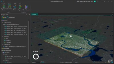
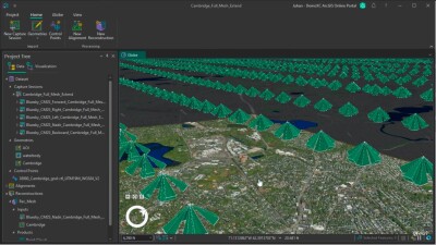
ArcGIS Reality Studio product demo
During the latest Esri UC in San Diego, a product demo of ArcGIS Reality Studio showed how a 3D mesh of Cambridge, Massachusetts was created with ArcGIS Pro and aerial images. The resulting mesh was added to an online WebScene, which is a core element of 3D mapping across the ArcGIS platform. The mesh was created by partnering with BlueSky, a company that acquires high-resolution aerial imagery with high aerial overlap. For capturing Cambridge, Massachusetts, they used the Leica CityMapper-2 aerial sensor.