
Last week I visited Toronto to meet with Optech president Don Carswell and vice president of sales and product strategy Brent Gelhar, who gave me a preview of the company’s forthcoming Lynx mobile mapper.
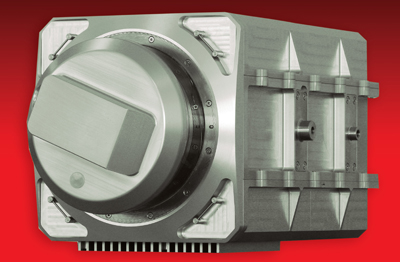
The new system has range well beyond 100m and can capture data at up to 100km/hr (62 miles/hr). With the system in motion, data postings and resolution can be achieved at up to 5cm (2in) performance, depending on the integrated inertial navigation solution (INS), Optech tells us. Lynx uses a new LIDAR sensor head developed by Optech that captures more than 100,000 measurements/sec with 360deg FOV while maintaining Class 1 eye safety rating. A turnkey solution for collecting and processing data, Lynx also includes an onboard passive imaging system and an integral Applanix POS LV navigation system.
This technology won’t replace millimeter total station work anytime soon – nor is it intended to. But for many engineering applications, 2-inch resolution from a moving platform is an order of magnitude better than can be achieved with airborne systems, for example – clearly in the realm of engineering-grade data, not planning-grade. We’ve been following the mobile capture market since early last year, and our conferences have featured this since 2006 – we think the combination of LIDAR, GPS and inertial navigation is a potent mixture that promises to rock the traditional survey and GIS worlds in ways that are difficult to foretell.
Lynx’s capture optics are housed in a cylinder in which they rotate for 360deg FOV. In its base configuration, it’s envisioned that a pair of capture optics will be mounted on top of a vehicle, one on each side, with the rotation axis set at 45 degrees to the direction of vehicle travel. (Of course if only one capture unit is deployed, it will be necessary to travel both up and down the corridor of interest to get complete coverage.) If needed, the system can support up to four LIDAR sensor heads.
Gelhar took care to point out that Lynx can be mounted on any kind of vehicle – surveying from an automobile, a rail vehicle, even a boat is within its reach. Gelhar sees demand for this capability emerging not only from traditional survey requirements, but also from new requirements for populating applications such as Google Earth and Microsoft Virtual Earth – tools that are inherently 3D and thus require more than just pretty pictures.
Company president Carswell has branded Optech as a LIDAR company, and sees the company’s role as a tool provider to this market. Gelhar adds that Lynx, as a turnkey mobile solution, fills a need formerly met largely by home-grown systems, and that its feature set and support plan will be familiar to users of its ALTM airborne LIDAR offerings.
Optech management is clearly bullish about its prospects. Its new building, which houses most of the company’s 200 employees, can accommodate up to 350. Carswell adds the company has an option to double this footprint by expanding into an adjacent parking lot.
Three years in development, the Lynx system will be manufactured in Optech’s new 65,000-sq-ft facility situated 15 minutes from Toronto’s Pearson International Airport and just down the road from Applanix, provider of the Lynx’s navigation system.
Gelhar tells us the new system will have a six-figure price tag. Our hunch is Lynx will cost more than a traditional 3D laser scanner but less than a conventional airborne LIDAR system.
General availability is planned for the first quarter of 2008. Gelhar reports the company has two firm committed pre-orders already.
Meanwhile, we expect to see more information on display in Optech’s booth at INTERGEO next week in Leipzig.


