

For more than 20 years, Geomap has been developing software for computer-aided facility management (CAFM). Across all of their solutions, they estimate that their software is used to manage more than 15 million square meters of property – in thousands of individual buildings. Their latest software solution combines a more visual, 3D-based approach to management of facilities and assets, and connects via the NavVis IndoorViewer.
To capture the scans, Geomap deploys the NavVis indoor mobile mapping system (a cart-based scanner) that can capture panoramic 360 degree views and point clouds. The images can then be displayed in NavVis IndoorViewer software, and the point clouds become facility floorplans.
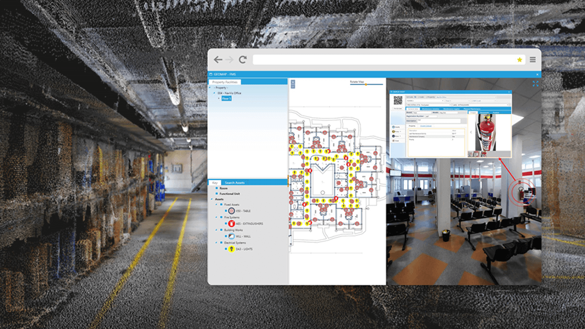
With Geomap’s integration, you can walk through a building and create assets as you are capturing information, rather than trying to match notes to a model after the fact. When a surveyor passes by an asset, they can capture a photo and note information about it. Because the scan and position is geo-referenced, the information that is captured is accurately and automatically placed in the correct position.
According to Andrea Paglialunga, Business Development Manager at Geomap, this process is far superior to the previous ‘1D’ process.
“In the beginning, people were managing their maintenance with an excel file – they would go out and write down all the information that we need. We call that ‘1D’ facility management.”
“Just imagine taking notes on paper. At the end, you’re going to get lost. With the survey application you’re going to get all the information you need,” says Paglialunga.
Mapping to 2D floorplans came next, which allowed managers to see the bigger picture of an entire facility at a glance. Floorplans created from point clouds, however, can replace outdated 2D drawings that are often used for facility management, providing a quick way to stay up-to-date. With the ability to update information at any time, Paglialunga says that increases accuracy.
“You are sure you are actually managing something that is based in reality.”
The collaboration between Geomap and NavVis began a year ago, and Geomap’s FM software is now integrated with the NavVis IndoorViewer. The combination allows users to look at all assets and view them directly, in place. For each asset and technical component created in IndoorViewer, a spreadsheet can be produced that contains additional information, including the dates of maintenance activities or requests.
Because each asset is geolocated, it can be individually or collectively managed, including adding preventative, predictive and corrective maintenance information, or managing associated documents. When using the integrated floor map, the interface allows you to click on an asset to view it directly – saving hours of travel and walking, especially for large-scale facilities.
Geomap’s 3D CAFM solution innovates by taking a 3D-first approach to managing building and facility assets. The result is a visual and user-friendly approach to facility and asset management – which should be valuable especially to those with large facilities to manage.


